Copper River Highway Mile 13-14 Areas of Concern
- View detailed information from the database on this site.
- Database Name: Copper River Highway Mile 13-14 Areas of Concern
- Status: Informational
- Location: Cordova
- Latitude: 60.485338
- Longitude: -145.437421
-
Key DBAC Services:
- Site Assessment
- DBACs Awarded: 2015
- DEC File Number: 2215.38.034
DEC Contaminated Sites contact: Joshua Barsis, 907-269-7691
Site Narrative
- Requested by Eyak Corporation & Native Village of Eyak
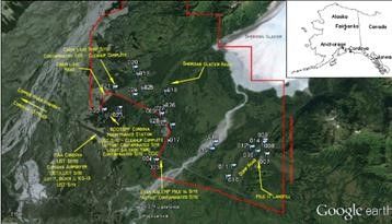
Aerial view of the mile 13-14 site outlined in red, Cordova, Alaska. Image courtesy of 2015 PACP report.
Mile 13-14, extending to mile 17-18 of the Copper River Highway contained areas with illegal dump sites, including drums. There is concern that the areas could be contaminated with lead, or petroleum or perhaps even dumped building materials that contain hazardous building materials. The community would like to restore the area to subsistence use.
In SFY 2015, the Eyak Corporation and Native Village of Eyak were awarded DBAC services to conduct a Property Assessment and Cleanup Plan (PACP). The report indicates two contaminated sites are located within the property boundary: Cabin Lake Shop (ADEC Hazard ID: 2085) in Cleanup Complete with Institutional Controls status and Eyak NALEMP Mile 14 Naval Radio Station (ADEC Hazard ID 25271) in Active status and could potentially be contamination source areas. While areas of staining were noted in one area, and there were multiple areas with solid waste present. Recommendations included removing the dumped materials to the landfill and collecting characterization samples to determine if contamination is present.