Adak Former Naval Air Facility
- Search for detailed information in the database.
- Database Name: The Adak Former Naval Air Facility site summary covers several sites in Adak. To access them in the database, choose "Adak" in the "City" dropdown function.
- Status: Active
- Location: Adak
- Latitude: 51.952269
- Longitude: -176.667694
- DEC Contaminated Sites contact:
- Jamie McKellar, Project Manager
- 610 University Avenue
- Fairbanks, Alaska 99709
- 907-451-5175
- U.S. Navy contact:
- Aaron Vernik, Remedial Project Manager
- Naval Facilities Engineering Command
- Northwest, 1101 Tautog Circle, Suite 203, Silverdale, WA 98315
- 360-396-0082
- U.S. EPA contact:
- Craig Scola, Remedial Project Manager
- EPA R10 Alaska Operations Office
- 222 W. 7th Ave, Box 19
- 907-271-1217 (office)
- Click on photos or maps for larger versions.
- Contacts updated: 2/16/2023
- Summary updated: 2/16/2023
Site Narrative

World War II bunkers on Adak Island. Photo by J. McKellar.
Description
The former Adak Navy Air Facility (NAF) is located near the center of the Aleutian chain, approximately 1,200 miles west-southwest of Anchorage, Alaska. The island is surrounded by the Bering Sea to the north and the Pacific Ocean to the south.
In 1942, the Adak Army Airfield was established, which gave the United States Army Air Force a forward base to mount a successful offensive against the Japanese-held islands of Kiska and Attu during World War II (WWII). The Adak Army Airfield was subsequently renamed Davis Army Airfield. Following WWII, Davis Army Airfield was transferred to the United States Navy and approximately 79,200 acres of the 180,000-acre island were set aside for Navy use. The Navy conducted multiple operations at the Adak Naval Air Facility/Naval Air Station through the 1990s. The Former Naval Air Facility was listed under the Base Realignment and Closure (BRAC) Program in July 1995. The military mission at Adak ended on March 31, 1997.
The former base had two areas with extensive development. The first was the "downtown" area, where the NAF was located. This area included an airfield, port facilities, landfills, sewage treatment facilities, light industrial, administration, commercial, recreational, and residential areas. The second main area was formerly used by the Naval Security Group Activity (NSGA) on the northern part of the island.
In September 2000, following the base closure, an agreement was signed by the Navy, U.S. Fish and Wildlife Service (USFWS), and The Aleut Corporation (TAC), which allowed the United States, acting by and through the Department of Interior (DOI) and the Department of the Navy, to enter into a land exchange agreement with TAC. The exchange took place in March 2004, with TAC receiving 47,271 acres of the northern portion of Adak, including the downtown area, port facilities, utilities infrastructure and light industrial, administration, commercial, recreation and residential areas. TAC exchanged surface and subsurface property from their Alaska Native Claims Settlement Act (ANCSA) entitlement lands, mostly in the Shumagin Islands. Under the terms of the land transfer agreement, the Adak airfield was transferred to the Alaska Department of Transportation and Public Facilities (ADOT&PG) for operation and maintenance. The associated land transfer agreement defines the limits of future environmental liability, set by both DEC and the U.S. Environmental Protection Agency (EPA).
Contaminated Sites
Through military operations over the years, releases of hazardous chemicals have occurred via spills, leaks, and historical disposal practices. The Navy has identified numerous sites with contamination from past Air Facility activities. In 1994, the former base was added to the National Priority List (NPL) of contaminated sites, under the terms of the federal Comprehensive Environmental Response, Compensation, and Liability Act (CERCLA). Beginning in the 1990s, the Navy, as the responsible party, has been involved in the environmental restoration, cleanup and closure activities , following the federal CERCLA standards for protecting people, animals, and the environment. The EPA provides oversight for CERCLA and munitions sites. The DEC Contaminated Sites Program oversees the cleanup to ensure that it meets the State of Alaska standards for protection of human health and the environment. The Navy, DEC and EPA seek community involvement via a Restoration Advisory Board (RAB), run by the Navy. RAB meetings are typically held in April and October.
In 1998, for technical and administrative purposes Adak was divided into two operable units (OUs), OU A and OU B,.
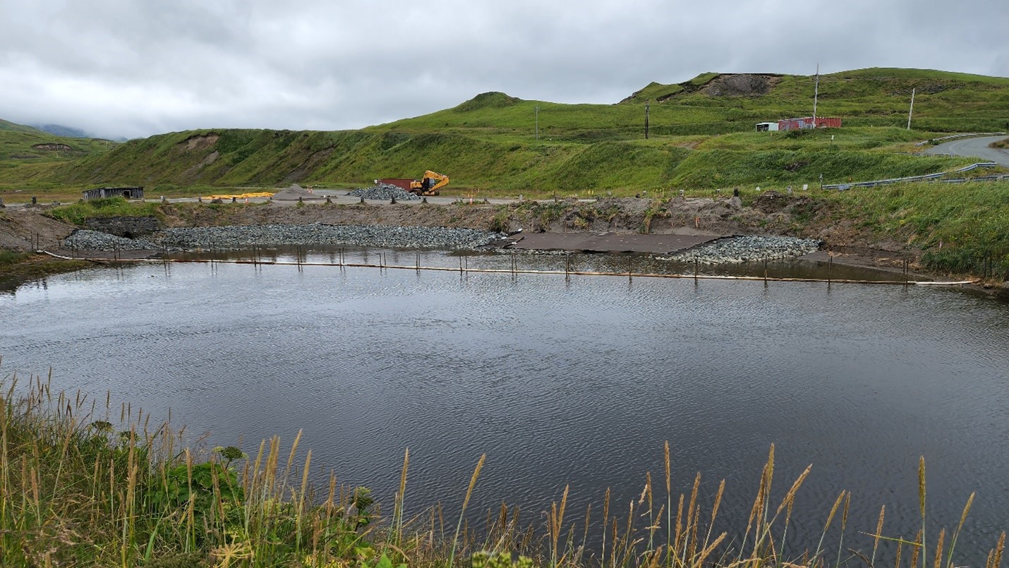
Installation of the oleophilic biobarrier (OBB) at South Sweeper Creek, downtown Adak area. Photo by J. McKellar.
Operable Unit A encompasses the entire military reservation with respect to chemical contamination. Cleanup and monitoring of sites within OU A is ongoing. Contamination has been identified in soil, surface water, sediment, and as free phase or dissolved contaminants in the groundwater. Sources of contamination include fuel tanks and lines, drum disposal areas, spill sites, pits for waste oil disposal/firefighting training, and landfills.
Surface waters in the area are used for sport, subsistence, and commercial fishing. Investigations considered the possibility of personnel being exposed to contaminants through the skin or accidental ingestion of contaminated soil or water. Exposure was also considered through ingestion of fish or shellfish that may have been affected by the site. Threatened ecological resources included migratory birds, wetlands, spawning and feeding fish, and various marine mammals.
Operable Unit B encompasses the entire military reservation with respect to ordnance contamination. Use of live ordnance on Adak was primarily limited to training ranges and their associated impact areas during the WWII era. Residual munitions contamination is associated with munitions storage, handling, and training. Operable Unit B includes two subunits, OU B-1 and OU B-2. The sites in OU B-1 include the downtown and remote exchange areas identified for transfer out of Navy control. OU B-2 includes areas in Parcel 4 that were retained by the U.S. Navy pending additional cleanup. As of 2022, the Navy was still completing munitions cleanup work in Parcel 4.
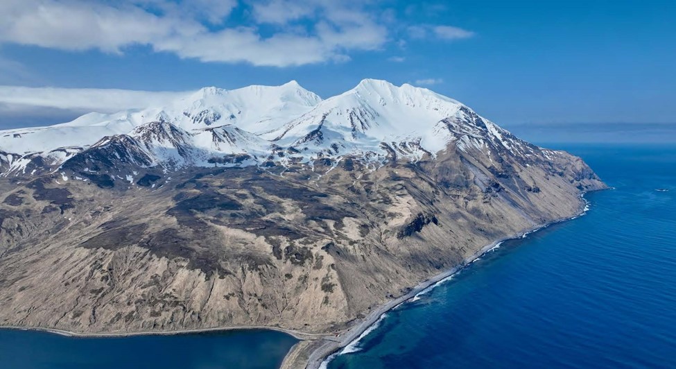
View of northern Adak – Photo provided by the US Navy, courtesy of Tom Spitler.
Institutional Controls
Institutional Controls are measures to prevent or limit exposure to hazardous substances left at a site and are an important part of the cleanup on Adak Island. Total cleanup of all hazardous substances is costly and at times impossible. Institutional controls on Adak Island include land use restrictions, fish advisories, excavation restrictions, and prohibition of groundwater use. Any excavation at any depth requires a dig permit from the Navy. Engineering controls such as fences, signs, and landfill caps are present throughout the island. Land use controls and an education program have been implemented to help educate residents and visitors about fish advisories, basic characteristics of unexploded ordnance (UXO) items, and procedures to follow if a suspected UXO item is encountered.
Major areas of work
- Since 1989: The Navy has removed hundreds of underground storage tanks, closed miles of fuel pipelines, and cleaned associated fuel-contaminated soil.
- 1990: The Navy and EPA signed a Federal Facilities Compliance Agreement to govern corrective action at hazardous waste sites.
- 1993: The Navy, EPA, and DEC signed a Federal Facilities Agreement to establish a procedural framework and schedule for CERCLA response actions.
- 1994: The Navy and DEC entered into the State Adak Environmental Restoration Agreement (SAERA) to address cleanup at petroleum sites in accordance with state and federal law. The initial SAERA included 26 petroleum sites. The SAERA specifies that petroleum sites will meet the regulatory requirements of the Alaska Administrative Code (AAC), 18 AAC 75.325 through 18 AAC 75.390.
- 1997: Remedial investigation and feasibility study were conducted to assess the risks to human health and the environment. This assessment resulted in an island-wide remedial program that included free product recovery and groundwater monitoring systems, sludge lagoon remediation, sediment removal and treatment, landfill restoration, and institutional controls to minimize the potential for exposure to contamination.
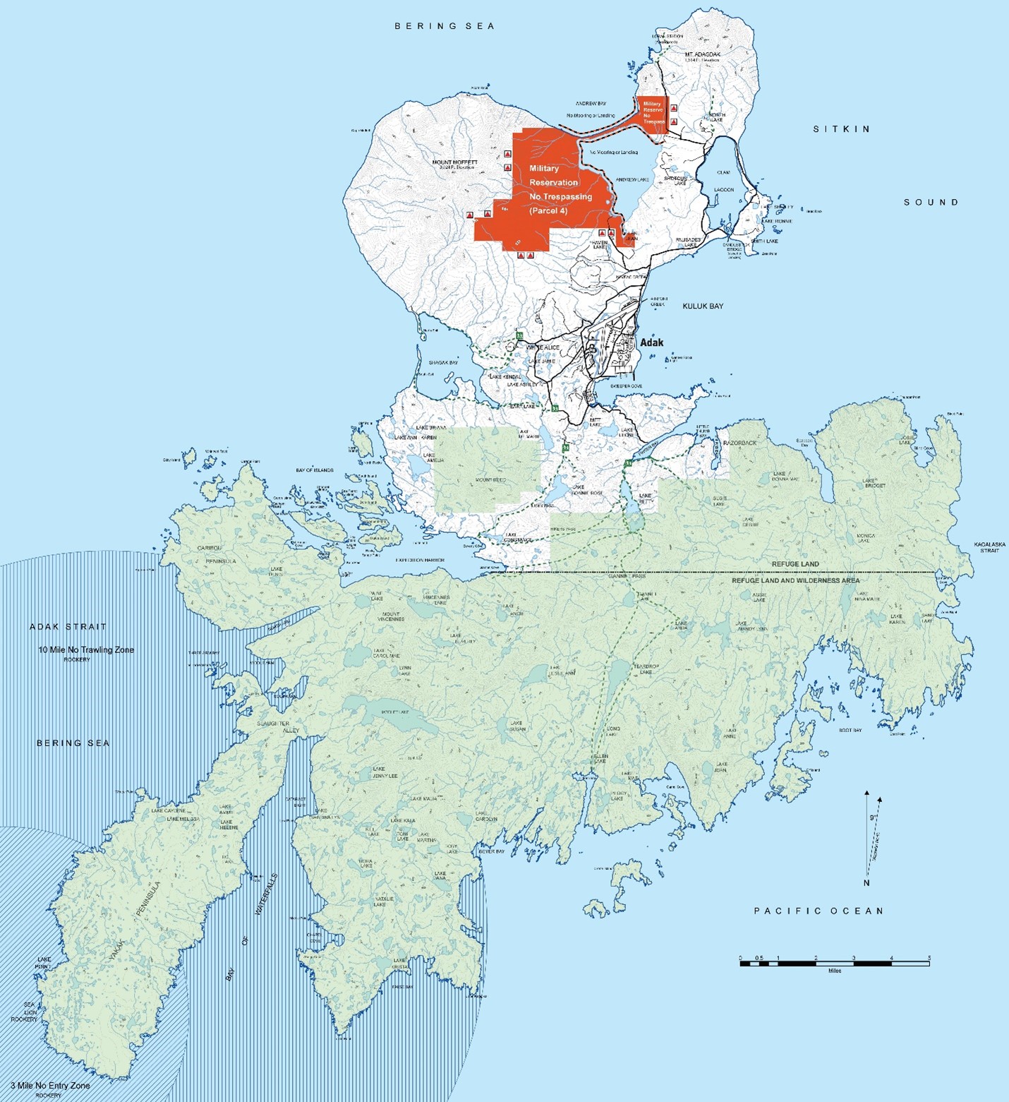
Adak Island Map (Courtesy: U.S. Navy)
- Late 1990s: Extensive UXO removal actions were conducted in the downtown Adak area.
- 2001: The OU B-1 Record of Decision (ROD) was signed by DEC, the US Navy and the Environmental Protection Agency. This record of decision was considered one of the first of its kind nationally because of the extensive involvement by the community, the future landowners, and other critical stakeholders in the development of the investigation and cleanup strategies. Much of the ordnance cleanup is already complete, and the rest will take place in the next few years.
- 2002: The Navy and DEC agreed to the 1st amendment to the SAERA on March 1, 2002. The amendment expanded the list of sites that would have all future remedial decisions for petroleum made pursuant to the Alaska regulations in 18 AAC 75.325 through 18 AAC 75.390. The 2002 1st SAERA Amendment included 62 petroleum sites.
- 2003: An amendment to the OU A ROD was signed. The amendment removes sixty-two (62) petroleum sites from the OU A ROD and clearly establishes Alaska's Oil Pollution Regulations, 18 AAC 75, as the basis for regulatory procedures and requirements for future petroleum cleanup decisions. Additionally, the OU A ROD Amendment modified the requirements for the subsistence fish advisory signs along the shores of Sweeper Cove and Kuluk Bay, replacing them with fact sheets to target the residents of the City of Adak. The fact sheets provide a greater level of detail on the presence of polychlorinated biphenyls (PCBs) in specific species, and discusses potential health risks and benefits associated with fish consumption.
- 2005: The Decision Document for Petroleum Sites with No Unacceptable Risks was signed by the Navy and DEC. This Decision Document outlined the selected remedies for 10 of the Petroleum Sites removed by the OU A ROD Amendment.
- 2006: The Navy and DEC agreed to the 2nd amendment to the SAERA on July 11, 2006. The 2nd to the SEARA 1) removed language that was no longer applicable because petroleum sites have been transferred from EPA/CERCLA authority to State of Alaska authority, updated the status of the 62 petroleum sites, and made other administrative changes.
- 2007: DEC amended closure criteria and required that surface water meet additional criteria (beyond absence of a sheen) after review of the Alaska Surface Water Quality Standards. This impacted monitoring and remedies at some Adak sites.
- 2008-2010: All OU B-1 remedial activities were completed with the Mount Moffett and Lake Jean work.
- 2009: A significant pipeline abandonment project was conducted, and former leaking pipeline areas affecting surface water were remediated in 2012 and 2016.
- 2012: The OU A Remedial Action Completion Report (RACR), the OU B-2 Remedial Investigation / Feasibility Study, an OU B-2 Action Memorandum, and an OU B-2 Proposed Plan were completed.
- 2013: A Non-Time Critical Removal Action (NTCRA) was initiated in Parcel 4 to address the remaining munitions impacts in OU B-2.
- 2014: The OU B-1 Remedial Action Completion Report was finalized.
- 2016: The Navy completed the fourth Five Year Review report for the former Adak Naval Complex.
- 2021: The Navy completed the fifth Five-Year Review for the former Adak Naval Complex.
- Today: Regular monitoring of soil, groundwater, sediment, and surface water is conducted at OU A sites and annual inspection of Institutional Controls is conducted per the Comprehensive Monitoring Plan. The OU B-2 NTCRA and remediation of high priority petroleum sites remain underway.

Northeast Adak: Lake Shirley, Clam Lagoon, and Mt. Moffett. Photo by J. McKellar.