Port Heiden Radio Relay Station
- View detailed information from the database on this site.
- Database Name: Port Heiden OT001 Composite Facility
- Status: Active
- Location: Port Heiden
- Latitude: 56.979990
- Longitude: -158.656770
- DEC Contaminated Sites contact: Ginna Quesada, Project Manager, 907-451-5960
- U.S. Air Force contact: Robert Johnston, Project Manager for Port Heiden, Air Force Civil Engineer Center, 907-552-7193 (Joint Base Elmendorf-Richardson)
- Click on photos or maps for larger versions.
- Contacts updated: 12/19/2022
- Summary updated: 2/15/2023
Site Narrative
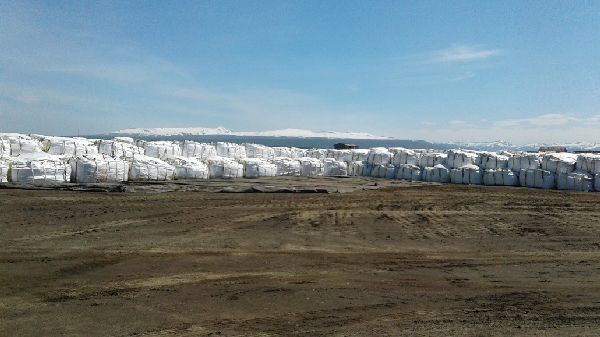
Super Sacks® of PCB-contaminated soil at the barge landing (2016)(Courtesy: Air Force)
Description
Port Heiden, pop. 118, is located at the mouth of the Meshik River on the north side of the Alaska Peninsula, 424 miles southwest of Anchorage. It’s a traditional Alutiiq community – many maintain a subsistence lifestyle and are involved in commercial fishing.
The community has two former military installations:
- Port Heiden White Alice Communication System (WACS) site, which later became the Port Heiden Radio Relay Station. A portion of it is still owned by the Air Force.
- Fort Morrow – The fort was a WWII Army Air Corps base and is now a Formerly Used Defense Site, or FUDS. (For more on Fort Morrow, see the link for it under Contaminated Sites Database reports at the bottom of this page.)
In 1942, the War Department acquired more than 1 million acres for Fort Morrow. The old fort consisted of several hundred buildings, housed as many as 5,000 personnel, and had a footprint covering several square miles. Then the site was abandoned following World War II.
In the 1950s, the Air Force acquired 172 acres within the former Fort Morrow and built a White Alice site. The WACS sites relayed signals from Distant Early Warning (DEW) defense communication sites to combat centers of the Alaska air command. Port Heiden was also one of the state’s 12 DEW-line radar stations.
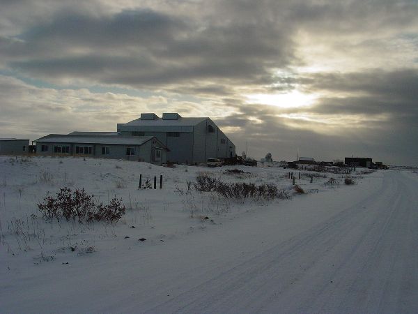
Port Heiden’s Meshik School (Courtesy: Air Force)
The 12 DEW-line stations, along with 18 Aircraft Control and Warning stations, were built in Alaska from 1950 through 1959, to detect possible attacks from the Soviet Union. The Aleutian segment of DEW-line stations included a main station at Cold Bay, and auxiliary stations at Port Heiden, Port Moller, Cape Sarichef, Driftwood Bay and Nikolski.
The WACS stations wove a telephone and telegraph network by bouncing both civilian and military communications signals off the earth’s troposphere, enabling combat centers to receive reports of aircraft detected by the DEW line. Each site had large parabolic, tropospheric antennas.
The antennas stood 60 feet tall and 60 feet wide. WACS linked the Aircraft Control and Warning stations and the DEW-line with Elmendorf Air Force Base (AFB) and Eielson AFB, and also linked the Ballistic Missile Early Warning Site at Clear AFB with the North American Defense Command. The systems eventually consisted of 71 separate facilities.
The Air Force operated the WACS in Port Heiden until 1969, when it was converted to a Radio Relay Station. Then the Radio Relay Station became obsolete in the 1970s. It was abandoned in November 1978.
The old village site for Port Heiden was Meshik, on the coast, but residents moved from there to higher ground near Port Heiden’s airport and the former Radio Relay Station facility.
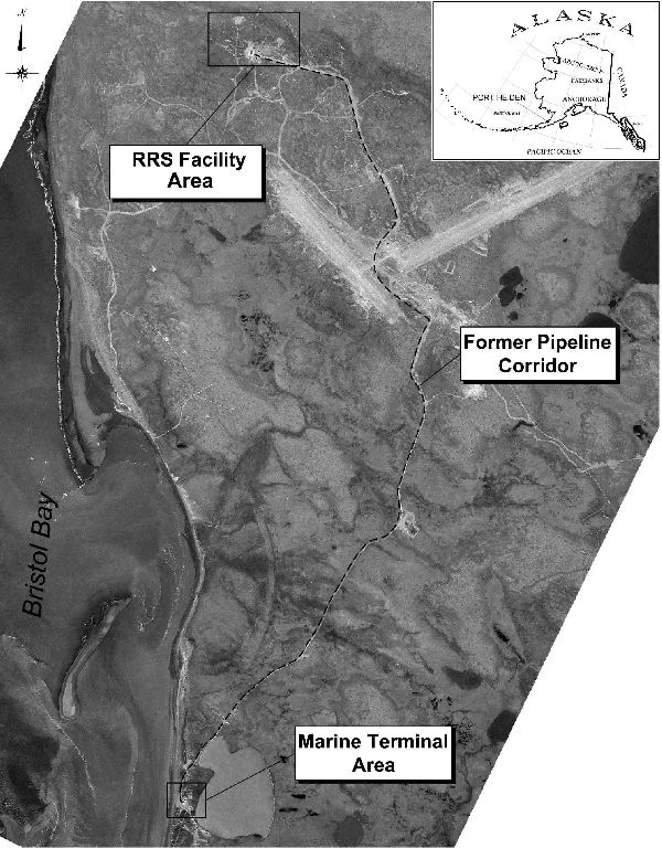
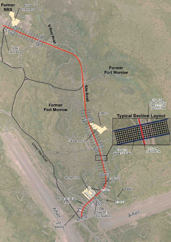
Area Map (Courtesy: Air Force)
The overall Port Heiden Radio Relay Station has three main areas: (1) the Radio Relay Station; (2) the Marine Terminal Area – the former location of a petroleum, oil and lubricant, or POL, tank farm and pump house; and (3) the Site Road/Former Fuel Pipeline Corridor, which is between the Radio Relay Station and the airport. (See the black and white map.) There are roughly 18 source areas at the overall site, and no buildings or structures from the radio relay station remain.
Public Health and Environmental Concerns
The soil still has PCB (polychlorinated biphenyls) hot spots, TCE (trichloroethylene) and other chlorinated solvents, diesel and other petroleum constituents. Groundwater contains TCE and other chlorinated solvents, diesel and other petroleum constituents. Multiple releases above-ground and below-ground occurred at the former facility.
People may be exposed to pollutants by touching contaminated soil or water (skin contact) or by accidentally ingesting contaminated soil or water. Contaminants such as PCBs that have bioaccumulated in fish and other wildlife may also pose a health threat to humans.
1981-1986: The Air Force 5099th Civil Engineering and Operations Squadron removed hazardous material and PCB-contaminated soil from the former Port Heiden Radio Relay Station facility (referred to as the former RRS facility here).
1986-1988: The U.S. Army Corps of Engineers (Army Corps of Engineers) conducted site investigations and prepared bid documents for the complete demolition and restoration of the former RRS facility.
1990-1992: The Army Corps of Engineers and its contractors conducted a complete demolition of the former RRS facility, and removed hazardous wastes and PCB- and petroleum-contaminated soil.
1995: The 611th Air Support Group (the Air Force) conducted a preliminary assessment and site inspection, which included collecting soil samples from the former RRS facility.
2000: The Air Force collected soil samples at those sites previously identified for further investigation.
2003: The Army Corps of Engineers, under the Native American Lands Environmental Mitigation Program (or NALEMP), sampled all private drinking water supply wells in the community of Port Heiden.
2004: The Air Force began the Remedial Investigation and Feasibility Study process to identify any remaining contamination and evaluate risks.
2005: The Air Force finalized the Remedial Investigation and Feasibility Study for work performed on 18 sites at the former RRS facility from May 2004 through September 2004. The field investigation included the collection of sufficient data to delineate the nature and extent of contamination present at the sites.
2008: The Air Force’s Proposed Plan selected excavation, washing and off-site disposal of PCB-contaminated soil in a permitted landfill as the preferred alternative for soil. For groundwater, natural attenuation and long-term monitoring (PDF) were the preferred alternative.
2009: DEC and the Air Force signed a Record of Decision. It required the excavation, soil-washing and disposal of PCB-contaminated soil in an off-site landfill. Long-term groundwater monitoring and institutional controls were the selected remedy for the contaminated groundwater. (An institutional control is a condition or restriction, usually long term, on a site to protect people and the environment from exposure to oil or a hazardous substance. It could range from a requirement to monitor soil or groundwater, to a fence or conservation easement. The institutional control stays with the land when it’s sold.)
2010: DEC issued a Compliance Advisory to the Air Force for the improper disposal of PCB-contaminated soil above the level stated in the landfill permit – 10 milligrams per kilogram (mg/kg). A compliance advisory is a letter that informs the responsible party of alleged violations of specific environmental regulations and provides deadlines for a response to comply with environmental regulations.
2011: The Air Force’s performance-based contractor successfully removed PCB-contaminated soil from the landfill and sent it to a permitted facility in the Lower 48. The Air Force began removing PCB-contaminated soil that was found in the road between the airport and the former RRS facility.
2012: DEC closed out the Compliance Advisory letter. The Air Force’s contractor for the Site Road cleanup successfully removed 19,129 cubic yards of PCB-contaminated soil and sent it to a permitted off-site disposal facility in Lower 48.
2013: The removal of PCB-contaminated soil by the Air Force’s contractor continued for the remaining contamination at Site Road – an estimated 5,000 cubic yards.
2014: First Five-Year Review for evaluation of remedy protectiveness OT001, WP002, SS004, LF007, and the Antenna Pads, Contaminated Soil Removal Areas, Drum Storage Area, and Focus Area. Based on the findings of this first five-year review, the actions performed for soil and groundwater at these sites are considered protective in the short‐term because exposures appear to be under control, and no unacceptable risks are occurring. Site Road PCB removal continues with 1,144.84 tons of PCB-contaminated soil removed. Landfarming activities continue for petroleum contaminated soil.
2015: Site Road PCB removal continues with 10,639.21 tons of PCB-contaminated soil removed in 2015. Landfarming activities continue for petroleum contaminated soil and results for diesel range organics are lower than 2014 results by 50 percent (4,300 mg/kg down to 2,130 mg/kg).
2016: Site Road PCB removal continues with 12,100.1 tons of PCB-contaminated soil removed in 2016. Landfarming activities continue for petroleum contaminated soil and test results are lower than 2015 results by 80 percent (2,130 mg/kg down to 442 mg/kg)
2017: Site Road PCB removal continues with 2360.47 tons of PCB-contaminated soil removed in 2017. Landfarming activities continue for petroleum contaminated soil and test results are lower than 2015 results by 25 percent (442 mg/kg down to 328 mg/kg).
2018: Explanation of Significant Differences (ESD) for increased quantities of PCB-contaminated soil and higher associated transport/disposal costs since the last ESD in 2010 from the Site Road excavation. No groundwater monitoring took place this field season due to funding delays and contractual issues.
2019: Second Five-Year Review (FYR) for evaluation of remedy protectiveness OT001, WP002, SS004, LF007, and the Antenna Pads, Contaminated Soil Removal Areas, Drum Storage Area, and Focus Area and first review for the Former Pipeline Corridor (SS006). Based on the findings of the FYR, additional studies will be required at the Black Lagoon Outfall Plume and Former Facility Area Plume to determine if the remedy, as is, will be able to achieve remediation goals within the estimated time frame. Land use controls (LUCs) will be implemented for soil at WP002, the Antenna Pads, Contaminated Soil Removal Areas, Drum Storage Area, and Focus Area. A groundwater LUC will also be implemented at the Black Lagoon Outfall Plume and Former Facility Area Plume. It is expected that these actions will take approximately 2 years to complete, at which time a protectiveness determination will be made.
2020: Land use control (LUC) warning signs were installed at Sites OT001, SS004, and LF007 and the monitoring well network was inspected and found in good condition. Soil sampling found DRO exceeding DEC cleanup levels. Groundwater monitoring found limited PCE/TCE degradation and while DRO continued to exceed DEC cleanup levels, concentrations of petroleum appeared to be decreasing. 4,651.89 tons of PCB-contaminated non-
TSCA soil and 95.81 PCB-contaminated TSCA soil was excavated and disposed of off-site. Approximately 450 tons of PCB-contaminated soil remains at the Port Heiden RRS and further delineation is necessary.
2021: Land Use Control (LUC) and landfill cap inspection activities occurred at the Former Composite Building OT001, the Landfill LF007, the Black Lagoon WP002, and the POL Pipeline SS006. Groundwater monitoring was also conducted at OT001, WP002, and SS006. TCE, Manganese, Total Petroleum Hydrocarbons (TPH) exceeded DEC cleanup levels at OT001 and WP002 and TPH exceeded DEC cleanup levels at SS006.
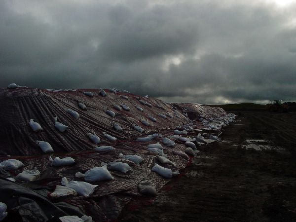
- Sandbags keep a tarp on a stockpile of soil contaminated with PCBs (polychlorinated biphenyls) from blowing away at Port Heiden. (Courtesy: Air Force)
Current Status
- Site Road/Former Fuel Pipeline Corridor, between the airport and the Radio Relay Station
- The most significant contamination in Port Heiden was the PCB-contaminated soil in this area. The cleanup is set to be done by September 2019.
- Radio Relay Station
- Most of the remaining contamination at Port Heiden is in the Radio Relay Station area. The soil still has PCB hotspots, TCE, diesel and other petroleum constituents, and the groundwater still has TCE, diesel and other petroleum constituents. Residual soil and groundwater contamination continues to be addressed through land-use controls and long-term groundwater monitoring. PCB-contaminated soil continues to be removed at the site. Alternative remedies are currently being considered to expedite the cleanup process at the site.
- Marine Terminal Area
- The contamination in this area was from petroleum, and the majority of the land that’s contaminated is now under the waters of Bristol Bay. There is little contaminated area that has not eroded away.
- Former Fuel Pipeline Corridor between the airport and the Marine Terminal Area
- There are areas of petroleum contamination in this area (Site SS006), and the Air Force is addressing them through land-use controls and groundwater monitoring.
Soil sampling for Site Road for the 2012 summer/fall field season. (Air Force/Jacobs map)
More Information
- Record of Decision for Port Heiden Radio Relay Station, February 2009, signed March 2009 (PDF 1.8M)
- Proposed Plan - Port Heiden Radio Relay Station, February 2008 (PDF 683K)
- Nearly all the Air Force documents on the Port Heiden cleanup are available on the Air Force site. Follow these instructions:
- Use the above link to get to the Air Force site
- Click "continue" at the bottom, then “Port Heiden RRS, AK” in the left column.
- Select the individual site and click “Search.” The documents will appear at the bottom of the page
- Superfund, or Comprehensive Environmental Response, Compensation and Liability Act (CERCLA)
- DEC's previous Web pages on Port Heiden, February 2008 (PDF 150K)
- DEC’s Glossary/Acronyms link is on the bottom of the Contaminated Sites Program’s home page.
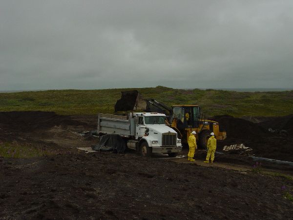
Air Force contractors work in protective gear while moving the PCB-contaminated soil.
General DEC Fact Sheets
- Cleanup Process for Contaminated Sites
- How DEC Makes Cleanup Decisions
- Introduction to Groundwater
- Understanding Contaminant Concentrations
- Department of Defense Cleanups
- Environmental Laws and Regulations
- "Environmental Cleanup Methods," June 2009 (PDF 171K)
- Human Health Risk Assessment
- Contaminants in Alaska
Other websites about Port Heiden
- Alaska Department of Labor and Workforce Development's Alaska Local and Regional Information on Port Heiden (Pull down “All Places” on the right to Port Heiden, then next to that, click "go." Then, in the section below that, click on "next.")
- Lake and Peninsula Borough
- Lake and Peninsula School District
- Bristol Bay Native Corporation (an Alaska Native Claims Settlement Act regional corporation)
- Bristol Bay Native Association, Inc. (a Tribal consortium)
- Native Village of Port Heiden
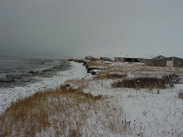
Meshik, Port Heiden’s old village site, is shown along the coast, south of the current-day Port Heiden. Residents moved from Meshik to higher ground near Port Heiden’s airport and the former Radio Relay Station facility, because storm waves had eroded much of the old townsite and threatened to destroy community buildings. Port Heiden incorporated in 1972. (Air Force photo)
Contaminated Sites Database Reports
There are a number of individual sites that are contaminated on Port Heiden, and reports on the status of each are available on DEC's database.
- Port Heiden OT001 Composite Facility
- Port Heiden SS006 POL Pipeline
- Port Heiden Drum Storage Area
- Port Heiden Antenna Pads
- Port Heiden WP002 Black Lagoon
- Port Heiden Contaminated Soil Removal Areas
- Port Heiden Focus Area
- Port Heiden LF007 Landfill
- Port Heiden - Fort Morrow FUDS
- Port Heiden AOC07 Landfill A (FUDS)
- Port Heiden AOC08 Landfill B (FUDS)
See reports on more sites, including closed ones in the area. (Choose “Port Heiden” in the city drop-down box.)