Red Devil Mine
- View detailed information from the database on this site.
- Database Name: BLM Red Devil Mine Site
- Status: Active
- Location: Red Devil
- Latitude: 61.762500
- Longitude: -157.308890
DEC Contaminated Sites contact: Anne Marie Palmieri, Project Manager, 907-766-3184
- Click on photos or maps for larger versions.
- Contacts updated: 2/17/2023
- Summary updated: 2/17/2023
Site Narrative
Site History
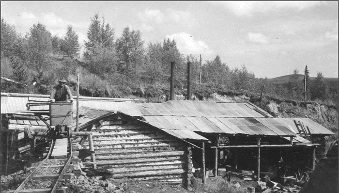
1940s era retort building and miner.
The Red Devil Mine is a historic abandoned mercury mine on the banks of the Kuskokwim River, 250 miles west of Anchorage and 1.5 miles southeast of Red Devil (pop. 23). The mine is on 10 acres of land managed by the Bureau of Land Management and has been selected by The Kuskokwim Corporation and Calista Corporation under the Alaska Native Claims Settlement Act (ANCSA).
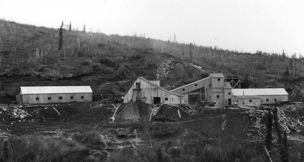
Mining at the site began in 1933. By 1939, mercury ore was being mined from creek sediments and overburden. The highly mineralized ore zone contained naturally high levels of antimony and arsenic in addition to mercury. The mine operated continuously until 1946 when the mercury market price dropped. During this period, a 40-ton rotary kiln was installed at the site for thermal processing of the mercury. Burned ore, referred to as tailings, and waste rock were deposited outside of the rotary furnace building into the drainage channel of Red Devil Creek.
Production began again in 1952 and continued until a fire destroyed the mine and mill equipment in 1954. Following the fire, a more efficient modern mercury furnace was built on the southeast side of Red Devil Creek, and it operated until 1971. Tailings and waste rock continued to be disposed of into the drainage channel of Red Devil Creek.
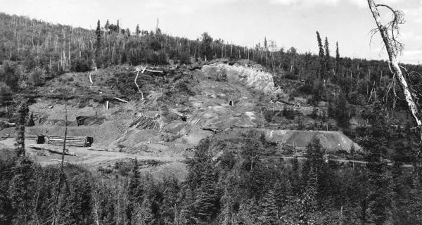
Extensive surface exploration and mining continued after 1956. Operations at this time included hydraulic sluicing, the washing of loose overburden through a sluice to recover ore. The waste material from the sluice operation was washed down a gully toward the Kuskokwim River. This resulted in the formation of the Dolly Sluice Area delta on the Kuskokwim River at the base of the gully. Surface mining also included trenching, bulldozing, and pit excavations over the hillside northwest of the mine area.
Open pit mining began in 1969, and by 1970, the Red Devil Mine was Alaska’s largest mercury producer, and it was one of the largest in the United States. The mine shut down in 1971 when the mercury market dropped and has not operated since. The underground mine itself flooded in 1981. During the mine’s lifetime, it produced roughly 35,000 flasks of mercury (76 pounds per flask).
The mine included a housing complex, equipment and chemical storage buildings, a shop pad (laboratory), an engine shop, mine portals, a power plant, a retort building, three settling ponds and five above-ground petroleum storage tanks. The BLM removed all the buildings in 2001 and the tanks in 2004. Most mining occurred underground in an extensive series of stopes – step-like excavations – and tunnels, but surface strip-mining and exploration were conducted above the retort area.
-
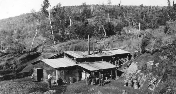
Images courtesy of the U.S. Geological Survey from the 1930s-1940s.
-
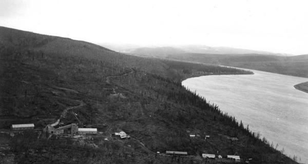
Images courtesy of the U.S. Geological Survey from the 1930s-1940s.
-
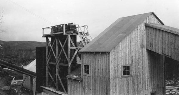
Images courtesy of the U.S. Geological Survey from the 1930s-1940s.
-
Images courtesy of the U.S. Geological Survey from the 1930s-1940s.
-
Images courtesy of the U.S. Geological Survey from the 1930s-1940s.
Contamination
The U.S. Environmental Protection Agency first inspected the site in late 1971 and collected water and sediment samples. Between 1979 and 2008, the EPA, Alaska Department of Environmental Conservation (DEC), the Bureau of Land Management (BLM), and U.S. Geological Survey conducted subsequent sampling investigations at the mine and surrounding areas.
Mine tailings had been used as fill across the site. The investigations showed elevated concentrations of metals in the tailings around the two different retort areas, in the sediment and surface water of Red Devil Creek, and in the groundwater on both sides of the creek. Petroleum-contaminated soil was found at several locations along the fuel pipeline and tanks.
From 2000 to 2004, the BLM demolished the buildings and fuel tanks and buried the debris on-site. Due to those BLM actions – operating heavy equipment on-site and moving tailings around – it was unknown if previous sample results were still representative of site conditions.
In 2005-6, the BLM removed petroleum-contaminated soil from the area of the five aboveground storage tanks and the fueling pipeline. Roughly 2,000 cubic yards of contaminated soil were stockpiled on-site awaiting treatment. In 2010, the petroleum-contaminated soil was moved to a cleared area and landspread on the ground surface to encourage naturally occurring microbes to break down the petroleum. Soil samples were collected to establish a baseline concentration and the soil was seeded to reduce possible erosion. The BLM is required to conduct annual sampling until the cleanup levels are met.
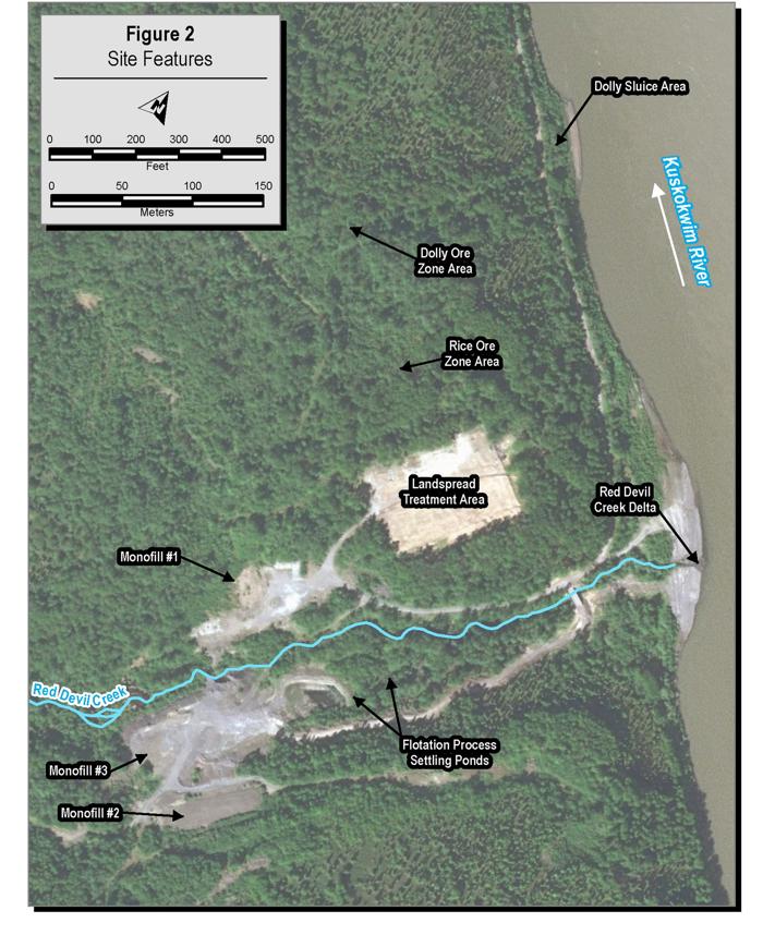
Map of site features at Red Devil Mine.
In January 2008, the EPA and DEC requested that the BLM conduct a comprehensive site characterization, called a Remedial Investigation, to determine the extent of the metals contamination in the soil, sediment, surface water. and groundwater, and a Risk Assessment to calculate health risks to humans, plants, and animals.
Starting in September 2010, the BLM conducted characterization efforts where its contractors collected soil samples, sediment and surface water samples from Red Devil Creek, sediment samples from the Kuskokwim River, and groundwater samples from groundwater wells. The BLM finalized the Remedial Investigation and Risk Assessment reports in 2014.
In 2014, sediment sampling results indicated that mine tailings were migrating into the Kuksokwim River via Red Devil Creek. The BLM, working with the U.S. Army Corps of Engineers, implemented an early action at the site to reduce the transport of contaminated tailings and waste rock from the site into the Kuskokwim River. In 2016, the BLM conducted a Feasibility Study to address contaminated tailings/waste rock, soil, and Red Devil Creek sediments.
In 2018, a Remedial Investigation Supplement was conducted to address data gaps associated with soil, groundwater, and Kuskokwim River sediments that were identified as part of the development of site-wide remedial alternatives during the preparation of the 2016 Feasibility Study. In addition, a Baseline Ecological Risk Assessment (ERA) Supplement was performed to assess potential risks to aquatic-dependent receptors that use the Kuskokwim River near and downstream from the Red Devil Mine.
Subsequent to the Remedial Investigation Supplement, the BLM performed additional characterization of groundwater and tailings/waste rock at the Red Devil Mine. The 2019 Groundwater and Surface Water report presents new results of the baseline groundwater and surface water monitoring performed in 2016 through 2018, as well as results of the additional characterization of groundwater and tailings/waste rock that was performed following the 2017 Groundwater and Tailings Characterization. The additional tailings/waste rock characterization generated additional information to assist with the design efforts associated with outlining the extent of excavation for tailings/waste rock and impacted soil from the Main Processing Area.
In 2019, following the completion of the Remedial Investigation Supplement and 2017 Groundwater and Tailings Characterization, the BLM prepared a Feasibility Study Supplement focused on groundwater and sediment in the Kuskokwim River.
Public Health and Environmental Concerns
The BLM completed assessments of human health and ecological risk based on the levels of contamination at the Red Devil Mine. A wide range of potential contaminants were included in initial studies of the site. This list of potential contaminants was then narrowed through a screening process to determine the contaminants of concern. The contaminants of concern identified as part of the risk assessments include antimony, arsenic, mercury, and other metals. A series of other metals were identified as contaminants of concern, but antimony, arsenic, and mercury are of the greatest concern. The study concluded that consumption of fish and plants/berries in the region were the relevant concerns around human health risk.
An Ecological Risk Assessment was completed to evaluate potential risks to plants, soil invertebrates, wildlife, and aquatic organisms in Red Devil Creek. The greatest arsenic risks were to plants, followed by soil invertebrates and two wildlife species, the masked shrew and common snipe. For these two wildlife species, the majority of their arsenic risk is from incidental ingestion of soil or sediment while feeding. Potential ecological risks from antimony and mercury followed a similar pattern to that for arsenic. The Main Processing Area, where contaminant levels in soil and sediment are greatest, contributed the most to the potential ecological risks from antimony, arsenic, and mercury at the Red Devil Mine site.
Current Status
In early 2020, the BLM issued its Proposed Plan detailing site information and cleanup alternatives outlined in the Feasibility Studies to gather comments on its preferred alternative from stakeholders and community members. BLM proposed an alternative which would remove all of the contaminated soil from the site, the former retort building and other debris buried in 2000-2004, and some sediment from the Kuskokwim River and place it in an on-site repository. Some of the highly contaminated soil would be stabilized to prevent the contamination from leaching. Some debris from the former retort building, such as the klin bricks, and any free-phase mercury would be sent for disposal off-site. Groundwater wells in the main processing area would be reinstalled and a long-term monitoring plan developed. Groundwater wells would also be installed downgradient from the repository. A long-term monitoring plan would be established for the repository which included inspection and maintenance, if required, of the repository cap and sampling of the groundwater wells.
BLM’s planned in-person public meetings about the Proposed Plan were cancelled due to the pandemic. A series of virtual meetings were held in October 2020 as part of their public comment period.
Since then, DEC reviewed BLM’s draft Record of Decision which outlined their selected alternative. DEC provided comments to BLM on the draft document and discussed how the State’s Applicable or Relevant and Appropriate Requirements (ARARs) could be achieved. BLM is reviewing the Record of Decision and will make a decision about the cleanup action. Once BLM signs the Record of Decision, they will obtain funding for the cleanup and begin planning the work. DEC will be involved in conducting oversight of the cleanup action at that time.