North Slope Geographic Response Strategies: Chukchi Sea Zone

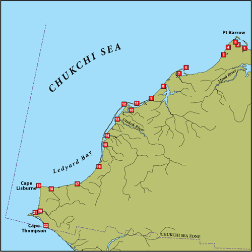
The workgroup selected 22 candidate sites for GRS development. The map shows the GRS selected sites, while the site selection matrix and site selection key summarize the resources at risk for each site. The site selection process took into consideration environmental sensitivity, risk of being impacted from a waterborne spill, and feasibility of successfully protecting the site with existing technology.
Site Selection Documents
Geographic Response Strategies (GRS)
Candidate sites only. GRS have not been developed for this region at this time.
- C-1 Avak Creek
- C-2 Mayoeak River
- C-3 Ikpik Slough
- C-4 Nunavak Bay
- C-5 Walakpa River
- C-6 Seahorse Islands
- C-7 Kugrua Bay
- C-8 Wainwright Inlet/Kuk River
- C-9 Nokotlek River
- C-10 Avak River
- C-11 Kasegaluk Lagoon
- C-12 Icy Cape Pass
- C-13 Utukok River
- C-14 Kokolik River
- C-15 Kukpowruk River
- C-16 Kuchiak Creek
- C-17 Pitmegea River
- C-18 Ayugatak Creek
- C-19 Cape Lisburne
- C-20 Kukpuk River
- C-21 Marryat Inlet
- C-22 Cape Thompson
GRS Updates Pending Approval
- Currently no updates pending approval
The Geographic Response Strategies (GRS) and tactics described on this site and in the area plans, are NOT prescriptive in nature. They are recommended deployment configurations for initial responders. They can, and should, be adjusted to fit the current situation and environmental conditions.
For More Information
- See the GRS Links menu on this page (includes links to GRS frequently asked questions, a site evaluation form, and more information on the site selection process)
- Contact DEC at dec.spar.grs@alaska.gov

 Indicates an external site.