Source Water Assessments
A Fact Sheet for Owners and Operators of Public Water Systems
What is Source Water?
Source water is the natural origin of the water you drink or use on a daily basis. Water that comes from under the ground, such as a well, is called a groundwater source. Water that comes from a lake, river or stream and uses an intake mechanism to supply a public water system with water is called a surface water source.
What is a Source Water Assessment?
A Source Water Assessment is produced through a process of gathering information about a community's or business's source of drinking water. Assessments for sources of public water systems (PWS) were completed statewide by the Alaska Department of Environmental Conservation (ADEC). The assessment provides owners and operators of a public water system with information on where their water supply comes from and what condition(s) and/or practices may pose a future potential threat to its quality. This information can then be used to develop long-term strategies to protect your drinking water source in the future.
In 1986 and 1996, Amendments to the Safe Drinking Water Act were adopted by Congress that required all states to develop and implement program elements to protect the sources of public water systems. In Alaska, a single program, known as the Drinking Water Source Protection Program (DWSP), was developed to implement these Amendments. The DWSP includes three components: source water assessments, groundwater protection, and wellhead protection. The United States Environmental Protection Agency (USEPA) funds the majority of this program. The first step in implementing the DWSP is the source water assessment that will identify and prioritize potential contaminant risks to public drinking water supplies. Owners, operators, and consumers can then implement appropriate protection efforts.
How is the Source Water Assessment Done?
The Basic Steps:
- We search public records from many agencies to gather information on the location of your drinking water source, as well as the surrounding area. This includes public water system wells and the areas along lakes, rivers, streams and ponds that supply water to your public water system. We also identify where the water comes from that contributes to the source of your drinking water and define a "protection area" around the source of your drinking water. This information is put on a map that covers the area of the PWS. A location map for each PWS is then sent to each public water system owner and/or operator to make sure it is correct. Any additional information provided to the DWWP is added to the map, which is used as the foundation for the Source Water Assessment of your drinking water.
- Any existing or potential contaminant source(s) found within the designated protection area of your drinking water source, is identified and ranked by the public health risk it poses to your drinking water source.
- The information gathered during the Source Water Assessment process is evaluated by DWSP staff to determine the level of potential public health risk to your public water system and a Source Water Assessment Report is produced, published, and given to the public water system owner.
What is Susceptibility?
Information about the construction and condition of the well or your water intake, in the case of a surface water source, along with information about the aquifer, allows us to determine your source water's "Natural Susceptibility."
An aquifer is a rock or ground formation that allows water to move through it. Depending on the formation, an aquifer may be a natural filter for your source water. Sand and gravel are natural filters, but fractured rock formations (bedrock) can allow surface water to flow into a ground water source, or sources, without naturally filtering it.
What Are Contaminant Risks?
The combination of the what, where, and how harmful the contaminant is, is called the "Contaminant Risk."
All identified existing contaminant sources are listed in an inventory found in the Source Water Assessment Report. "Existing" means something that is already contaminating the soil or water like a septic system or leaking underground fuel storage tank.
Potential contaminants are also identified and considered. "Potential" is something that hasn't released contaminants into the soil or water yet but could in the future, like a fuel tank which could be above or below ground.
After potential and existing contaminant sources are identified, they are categorized into six basic contaminant groups:
- Bacteria & Viruses
- Sewage lagoons, septic systems, etc.
- Nitrates & Nitrites
- Septic systems, fertilizers, manure piles, etc.
- Volatile Organic Chemicals
- Gasoline and other fuels
- Heavy Metals and Cyanide
- Can be found in industry or landfills
- Synthetic Organic Chemicals
- Pesticides, herbicides, etc.
- Other Organic Chemicals
- Dioxin, PCBs, etc.
All contaminants within each group are ranked as very high, high, medium, low or very low risk, based on the level of threat to public health.
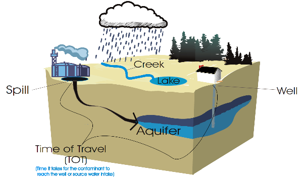
We also consider where the source of contamination is located, and how long it will take to reach the well or source water intake. The amount of time it takes a contaminant to get to the well is called "Time-of- Travel" (TOT), and is determined by the type of aquifer.
The protection area around the drinking water source is categorized into zones depending on the distance from the drinking water source. You can use the following table to help read the map that is in your PWS’s Source Water Assessment Report.
Ground Water Source
- Zone A = several months TOT or less to the well
- Zone B = two years TOT or less to the well
- Zone C = five years TOT or less to the well
- Zone D = ten years TOT or less to the well
- Zone E = 1,000 feet from the edge of the surface water
- Zone F = 1 mile from the edge of the surface water
- Zone G = The entire watershed
Surface Water Source
- Zone A = 1,000 feet or less from the edge of the surface water
- Zone B = 1 mile (or less) from the edge of the surface water
- Zone C = The entire watershed
What Is Vulnerability?
Information about the natural susceptibility and the contaminant risk is combined to achieve the "Vulnerability" of your source water to all the contaminant categories. Vulnerability is defined as:
- Contaminant Risk + Natural Susceptibility = Vulnerability
What Will I See in the Source Water Assessment Report?
The Narrative
- Executive Summary
- Tells you the vulnerability of your source water.
- Introduction
- Tells you why the assessment was done.
- Physiography
- Is a detailed description of the physical aspects of the entire protection area that surrounds your source of drinking water. It explains the geography and geology of the area and/or the area of the surface water.
- Public Water System
- Specific information about your public water system. It includes things regarding the location of the well or surface water intake or treatment system, the soil type around the well, and the water level in the well.
- Protection Area
- Explains the protection zones.
- Inventory of Contaminants
- Identifies existing and potential sources of contaminants that were found in the protection area. Each contaminant source is then categorized by contaminant group.
- Ranking of Contaminants
- How the contaminants were ranked within the protection area.
- Vulnerability
- Explains how we came up with the numerical score of vulnerability for your source water, along with what was taken into consideration when the area was evaluated. Table 1 of this section gives you the Susceptibility of the wellhead, or water intake, and the source water, to contamination and explains how the score was determined. Table 2 gives you the ratings and rankings of the Contaminant Risk and lists those scores for the six categories (groups) of contaminants. Table 3 adds these scores together to give you the Vulnerability of your drinking water source to contamination.
- Summary
- Summarizes all the information for your assessment area.
Appendix A
Contains a set of maps that shows the assessment area, location of source water, wells, intakes and the protection area zones.
Appendix B
Contains the inventory or lists of existing and potential contaminants found in your assessment area, and their risk ranking.
The first table is a list of all the identified potential and existing contaminant sources in the assessment area.
The second table is a list for each of the six groups of contaminants found. The contaminant sources are separated and put into each of their respective groups.
Appendix C
Contains maps of existing and potential contaminant source locations, along with the information from Appendix A.
Appendix D
Flow charts and tables that explain how the numeric scoring was done. There is one set of charts for each of the six groups of contaminants.
Appendix E
If you have a well in a flood plain you will have Appendix E, which is a map of the protection areas' flood plain.
Get Involved and Plan for the Future!
What Can I Do to Protect Our Drinking Water?
The assessment report explains the potential vulnerability of the source water protection area for your drinking water source and provides that information to the PWS owner and/or operator, local governments, regulatory agencies, communities, and the public to help in planning and coordinating protection efforts. The assessment report is a tool that you can use to help protect your public drinking water supply. You are a part of “the big picture” in making sure your drinking water is protected.
Non-Regulatory Options
- Public education about where your drinking water comes from, and how contaminants affect it is probably the most effective and least costly method of protection.
- Household hazardous waste collection - household hazardous wastes are usually generated in small amounts but can have a big impact on the environment.
- Taking proactive measures on proper waste storage and disposal can help eliminate the need for you to find an alternative drinking water source by preventing source water contamination.
- Conservation easements - easements can assist in protecting the area by limiting development.
- Make a plan on what you will do if an accidental spill happens that could contaminate your source of drinking water.
Regulatory Options
- Source protection regulations prohibit the presence or use of all or specific chemicals within the drinking water protection area.
- Zoning ordinances can control development within the different protection areas around the source.
- Local drinking water protection plan (an example or template is available from ADEC).
- Subdivision ordinances.
- Operating standards for industrial and other activities within the different protection areas around the source.
Be informed & get involved, and for more information about ground water protection check out these web sites:
 Indicates an external site.