Cook Inlet Geographic Response Strategies: Kachemak Bay Zone

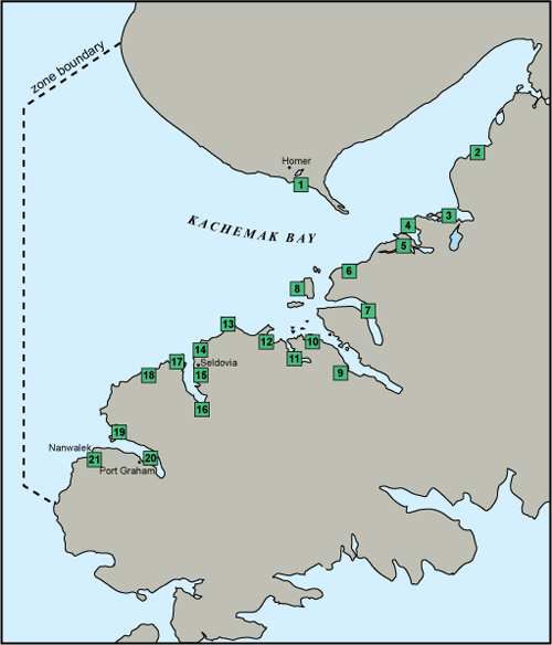
The workgroup selected 21 sites from the list of candidate sites for GRS development. The map shows the GRS selected sites, while the site selection matrix and site selection key summarize the resources at risk for each site. The site selection process took into consideration environmental sensitivity, risk of being impacted from a waterborne spill, and feasibility of successfully protecting the site with existing technology.
Site Selection Documents
Geographic Response Strategies (GRS)
- KB-01 Beluga Slough (PDF 746K)
- KB-02 Humpy Creek (PDF 777K)
- KB-03 Halibut Cove (PDF 799K)
- KB-04 Peterson Bay (PDF 790K)
- KB-05 China Poot Bay (PDF 809K)
- KB-06 Neptune Bay (PDF 773K)
- KB-07 Sadie Cove (PDF 894K)
- KB-08 Yukon Island West (PDF 728K)
- KB-09 Tutka Bay Lagoon (PDF 733K)
- KB-10 Little Tutka Bay (PDF 701K)
- KB-11 Jakolof Bay (PDF 886K)
- KB-12 Kasitsna Bay (PDF 820K)
- KB-13 Barabara Creek (PDF 749K)
- KB-14 Seldovia Outside Beach (PDF 827K)
- KB-15 Seldovia Slough (PDF 524K)
- KB-16 Seldovia River (PDF 736K)
- KB-17 Hoen's Lagoon (PDF 716K)
- KB-18 Fourth of July Creek (PDF 1.3M)
- KB-19 Johnson Slough (PDF 865K)
- KB-20 Port Graham (PDF 697K)
- KB-21 English Bay (PDF 815K)
GRS Updates Pending Approval
- Currently no updates pending approval
The Geographic Response Strategies (GRS) and tactics described on this site and in the area plans, are NOT prescriptive in nature. They are recommended deployment configurations for initial responders. They can, and should, be adjusted to fit the current situation and environmental conditions.
For More Information
- See the GRS Links menu on this page (includes links to GRS frequently asked questions, a site evaluation form, and more information on the site selection process)
- Contact DEC at dec.spar.grs@alaska.gov

 Indicates an external site.