Potential Places of Refuge for Alaska

Potential Places of Refuge (PPOR) are pre-identified sites that may aid decision-makers in responding to vessels in distress. These plans are tailored to protect sensitive areas from impacts from possible spills and are map-based to save time during the critical first few hours of a vessel response.
Geographic Zones
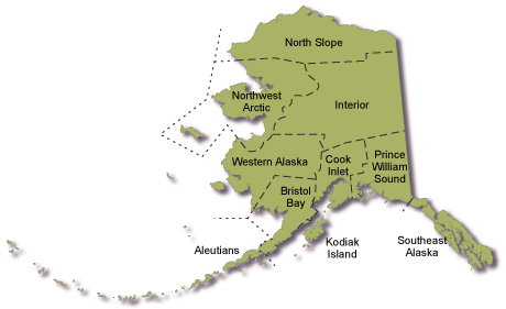
For the purposes of oil spill planning, Alaska has been divided into ten geographic zones. PPOR have been developed within each zone by workgroups under the Area Committee's governance. PPOR workgroup participants include State and Federal resource trustee agencies, local spill response experts, and local stakeholders. Public involvement is essential to ensure the places selected reflect the environmental protection priorities of local communities, stakeholders, and resource users.
At present, PPOR have not yet been developed for the Interior Geographic Zone.
Project Background
Leaking or disabled vessels may require a sheltered location with adequate water depth to repair or lighter the vessel in order to minimize the amount of spilled product. If disabled vessels are not repaired, oil or other hazardous substances released from the vessel can impact downstream environmental resources and shoreline. Vessels should be anchored or moored in protected waters to safely undergo repairs and minimize polluting the environment.
In addition to sensitive shoreline habitats such as marshes, sheltered tidal flats, and exposed tidal flats, several of these areas support a number of sensitive biological resources including birds, fish and shellfish, and marine mammals. They contain national refuges, state critical habitat areas, state parks, native and other private lands, and are managed for a variety of uses. Some of the areas are also widely used for marine commerce. Tankers, tramper vessels, log transport ships, fuel and freight barges, freighters, ferries, and large passenger vessels make routine stops at these ports. Also, commercial fishing boats, sport fishing charter boats, and privately owned vessels regularly use local harbors and docks.
Anchoring or mooring large vessels generally requires water depths 30 fathoms or less. In addition, labor and necessary equipment must be available to make repairs or to lighter product. Suitable emergency mooring locations were pre-identified to expedite the response process.
Choosing A Place of Refuge
There is no perfect mooring or anchoring site for all vessels and all situations. Larger vessels, such as oil tankers and freighters, cannot be taken to certain locations. Some ports may have shallow approaches or small-sized bays, and large ships cannot enter these locations. But smaller vessels, such as fishing vessels and charter vessels, may be able to utilize these smaller sites. Decision-makers must address both environmental and operational issues when deciding where to take stricken vessels.
The decision-makers may use the collected information to refer to pre-identified sites that may aid them in responding to a vessel in distress. Potential anchoring or mooring sites identified in these plans were reviewed by state and federal agencies, the Alaska Marine Pilots Association, the marine crude oil shippers, local communities, and oil spill response cooperatives. This ensures that the information contained in the plans is correct and useful to decision makers in the event a vessel needs assistance. The U.S. Coast Guard Captain of the Port (COTP) has jurisdiction over approving temporary mooring or anchoring locations for leaking or damaged vessels. The COTP will confer with state and local officials when deciding where and when to move a stricken vessel. Prior coordination and pre-identification of potential places of safe refuge significantly enhances the decision-making process and facilitates the overall response operation.
Another workgroup, convened by the Alaska Regional Response Team (ARRT), has developed guidance on the decision-making process for choosing a place of refuge at the time of an incident. That workgroup used the lessons learned from previous incidents and drills to create the decision-making template for places of refuge. The local COTP will use these guidelines if a situation arises that may require a vessel be moved to a place of refuge. The guidelines developed by the ARRT workgroup address two major problems:
- What decision-making procedure is used to allow a ship in distress into a place of refuge
- What process is needed to conduct pre-incident planning to identify acceptable potential places of refuge
ARRT Guidelines for Places of Refuge Decision-Making (PDF 165K)
Each vessel incident presents unique circumstances that must be addressed. The goal is to safely repair or salvage a damaged vessel while avoiding or minimizing impacts to local resources. Prior to bringing a vessel into an anchoring or mooring location, the following factors needs to be considered:
- Status of the vessel
- Public safety
- Environmental resources at risk
- Strategies to protect sensitive areas
- Prevailing winds
- Navigational approach to the mooring site
- Anchoring ground
- Vessel traffic
- Available dock and support facilities
- Available skilled and spill response labor
- Economic concerns and potential impacts
Objective
The objective of this project has been to identify docking, anchoring, mooring and grounding locations that may be selected as Potential Places of Refuge in order to enhance the overall response process.
The workgroup process was open to the public and public participation was welcomed and encouraged. The workgroup's record is available for public review.
For More Information
- For additional information regarding Potential Places of Refuge or the workgroup process, or if you have local knowledge about the portions of coastal Alaska for which PPOR are presently developed please contact: dec.spar.ppor@alaska.gov
 Indicates an external site.