Peger Road Maintenance Station
- View detailed information from the database on this site.
- Database Name: DOT&PF Peger Road Facility
- Status: Active
- Location: Fairbanks
- Latitude: 64.825963
- Longitude: -147.769907
DEC Contaminated Sites contact: Michael Hooper, Project Manager, 907-334-5939 (Anchorage)
- Click on photos or maps for larger versions.
- Contacts updated: 11/7/2025
- Summary updated: 12/31/2025
Site Narrative
Description
This site has soil and groundwater contaminated with chlorinated solvents and petroleum associated with maintenance activities at the Alaska Department of Transportation and Public Facilities (DOT&PF) facility on Peger Road in Fairbanks. The contamination was first discovered in 1991 when an underground diesel storage tank was being decommissioned.
The DOT&PF Peger Road facility includes the Maintenance and Operations (M&O) building, Materials Laboratory, Technical Services, the Cat House (where Caterpillar tractors are stored), a seasonal laboratory, State equipment fleet/maintenance shop, a Bridge Shop building, equipment wash-down areas, and areas where other equipment has been stored.
Public Health and Environmental Concerns
Groundwater and some soil contaminated with chlorinated solvents and petroleum are the main threat to public health and the environment. Contaminated soil and groundwater are present on the DOT&PF property, and contaminated groundwater travels off the property.
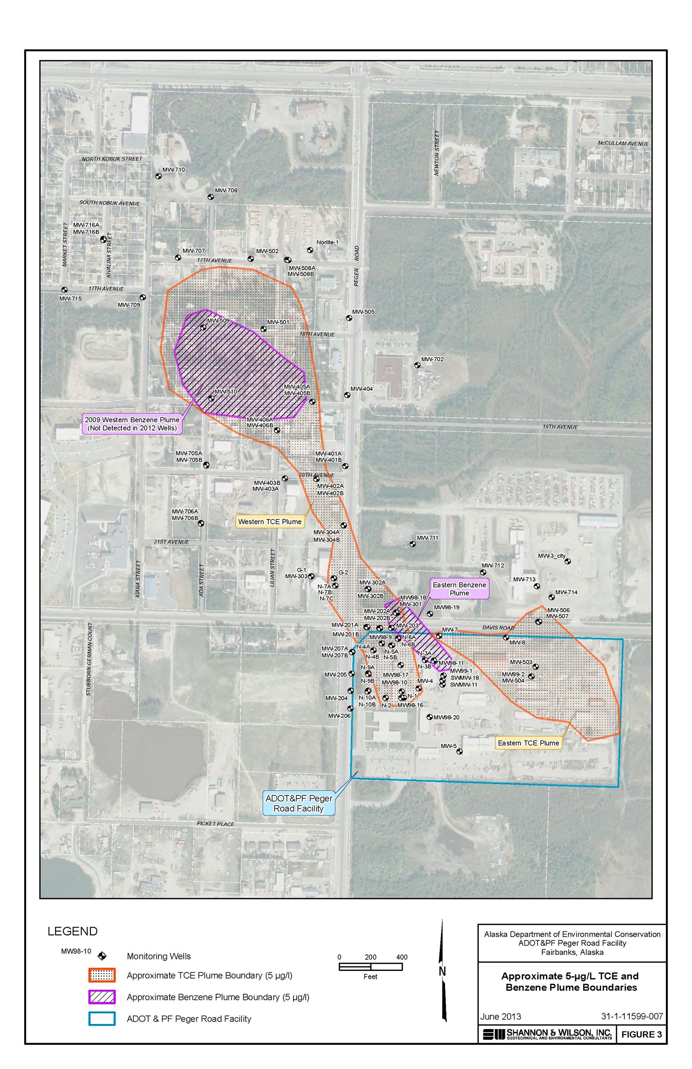
Four contaminated groundwater plumes have been observed at the site.
Two of the plumes contain chlorinated solvents. One of the chlorinated solvents in greatest abundance is called trichloroethylene (TCE) – a common industrial degreasing and machine cleaning agent. Other chlorinated solvents, such a trichloroethane (TCA) have also been detected.
TCE is “reasonably anticipated to be a human carcinogen,” according to the federal Agency for Toxic Substances and Disease Registry (ATSDR), and the National Toxicology Program. It affects people’s health, even by breathing small amounts or drinking small amounts of water contaminated with TCE.
It’s unknown whether TCA causes cancer, or how breathing or swallowing it affects human health. But it affects animals that breathe or swallow it, causing damage to the liver, kidneys, blood, stomach and nervous system, according to the ATSDR.
Two other plumes contain benzene contamination. Benzene is a petroleum compound and known carcinogen – it causes cancer in people and animals. It’s widely used in the Unites States, and is associated with fuel, such as gasoline.
For more information about exposure to chlorinated solvents and petroleum, contact the DEC Project manager listed above or search the ATSDR ToxFAQs™ website.
It is likely that Per- and polyfluoroalkyl substances (PFAS) are also present in groundwater as a groundwater plume from the City of Fairbanks Fire Training Center has migrated through this and nearby properties. More information about PFAS contamination from the Fairbanks Fire Training Center can be found on DEC's website.
DEC's regulations outline the concentrations of a hazardous substance that may be left in soil or water without posing a threat to human health, safety or welfare, or to the environment. These cleanup levels may be chosen depending on the contaminants present, the soil types, depth to groundwater and whether or not the hazardous substance could be taken in through breathing, skin contact, or eating/drinking contaminated materials. DEC's groundwater cleanup level for TCE is 2.8 parts micrograms per liter (µg/L). Meanwhile, the groundwater cleanup level for benzene is 4.6µg/L. The methods to establish groundwater cleanup levels statewide are in state regulation.
The public drinking water maximum contaminant levels (MCLs) for both TCE and benzene is 5 µg/L. MCLs are the maximum levels of certain contaminants that are permitted in public drinking water supplies, established by the U.S. Environmental Protection Agency.
Here is the current situation with contaminated groundwater plumes associated with the DOT&PF Peger Road facility:
- The Western TCE Plume. This is the major plume at the site. It overlaps with the Western Benzene Plume and extends off the DOT&PF property to the northwest into commercial and residential neighborhoods.
- The Eastern TCE Plume. This plume appears to extend off the DOT&PF property in both a northerly and easterly direction.
- The Western Benzene Plume. This plume's boundaries, as shown on the map of the plumes (right), are based on 2009 sampling results. When the same wells were sampled in 2012, benzene was still in the wells, but the amount of benzene was below DEC’s 5 µg/L groundwater cleanup level.
- The Eastern Benzene Plume. This plume also appears to be diminishing in size, similar to the Western Benzene Plume.
What is vapor intrusion?
Chemicals such as the chlorinated solvents and petroleum chemicals at this site are volatile and release significant fumes or vapors. When these Volatile Organic Compounds (VOCs) are released into the soil or groundwater, a certain amount of the chemical vaporizes into the small air spaces within the soil. The larger the chemical spill and the more volatile the chemical, the more chemical vapors move into the air spaces. This air is called soil gas. If the air pressure inside the building is lower than in the soil, or if the amount of chemicals in the soil gas is high, the vapors move, or intrude, into any open space, such as cracks in foundations, crawl spaces and basements. People in buildings can sometimes smell a chemical, but often the chemicals are odorless or too faint to smell while still being above the levels safe for long-term exposure.

The above overhead view shows the DOT&PF facility, which is at the southeast corner of Peger and Davis roads in Fairbanks. (Map from Shannon & Wilson, Inc.)
Current Status
Since the 2012 site investigations, additional private well monitoring and evaluation of vapor intrusion risk has been conducted. An additional source/release location of solvent contamination in soil and groundwater was also delineated in 2016 near the eastern property boundary. Vapor intrusion risks for buildings on the DOT&PF Peger Road Facility have been evaluated during air sampling events occurring since 2015. Results from recent sampling efforts are summarized below:
- The Western TCE Plume - The major plume extending from the DOT&PF facility northerly to 17th Avenue and westerly toward Kiana Street appears to be stable and decreasing in concentration. Additional periodic monitoring is expected.
- The Western Benzene Plume - Detections of benzene west of Peger Road are currently below regulatory cleanup levels.
- The Eastern Benzene Plume - Comingling the western TCE Plume, the eastern benzene plume spans across Davis Road. Additional periodic monitoring is needed.
- The Eastern TCE Plume - Additional sources of solvent contamination were discovered from 2010 to 2012 at the eastern property boundary of the DOT&PF Peger Road facility. This source was further defined in 2016, where results identified solvent contamination in both soil and groundwater contamination that likely extends offsite to the east.
- Offsite Residential Wells - Offsite receptors (including drinking water or irrigation wells) are affected by the Western TCE and Benzene Plumes, but those wells have contaminant concentrations that are relatively low and below the public drinking water MCLs of 5 µg/L. These wells were last sampled in 2014 and were again below public drinking water levels of concern. Many residences have since been connected to municipal piped water as part of the response actions by the City of Fairbanks to PFAS contamination in groundwater, associated with the Fairbanks Regional Fire Training Center (near the Mitchell Expressway). The only remaining residential well was sampled in 2020 for solvents associated with the DOT&PF Peger Road Facility. Test results for the solvents were non-detect or below levels of concern. PFAS, presumably from the City of Fairbanks Fire Training Center mentioned above, was present in this well. DEC understands this well is not used for drinking water.
- DOT&PF Peger Road Facility Vapor Intrusion - Soil gas and indoor air samples have been collected from various locations on the DOT&PF Peger Road facility since 2017. As of 2020, results seem to indicate that vapor intrusion is not occurring at the Main Office Building, Cat House, or Bridge Shop based on soil gas results below the target levels. Vapor intrusion concerns still exist at the M&O Building and Materials Lab. Both of these structures have sub-slab depressurization systems that are effective in protecting indoor air. The results of indoor air samples collected in 2020 were all below DEC's vapor intrusion target levels.
- Down-gradient Soil Gas - In 2016 soil gas was collected from vapor monitoring points installed in the western TCE plume where it extends off the DOT&PF property into the Jones subdivision. TCE concentrations were elevated in soil gas but below the vapor intrusion target levels in the residential neighborhood.
What's Next
In Fall of 2025, DEC contractors investigated vapor intrusion and sub-slab depressurization system effectiveness at the M&O shop and Materials Lab through collection of indoor air and sub-slab soil gas samples, results are currently pending.
Future work occurring at this site may include:
- Continued monitoring of vapor intrusion at the DOT&PF Peger Road Facility.
- Periodic groundwater monitoring through sampling of monitoring wells on and off the DOT&PF property.
- Sampling of private wells as necessary.
- Additional site characterization relating to the source of the east TCE Plume
DEC will also continue to coordinate investigative efforts with the various responsible parties of this and other contaminated sites in the area to determine if they are contributing to the area-wide groundwater contamination.
More Information
Documents related to this contaminated site can be found on the Contaminated Sites Program database. More information about contaminants can be found in the links below: