Fort Wainwright, Taku Gardens (102 Comm. Site)
- View detailed information from the database on this site.
- Database Name: Fort Wainwright (OU-6) Taku Gardens (102 Comm. Site)
- Status: Active
- Location: Fairbanks
- Latitude: 64.824485
- Longitude: -147.665143
- DEC Contaminated Sites contacts:
- Carly Jensen, Primary Remedial Project Manager (Wasilla), 907-269-3077
- Juliana Smit, Alternate Remedial Project Manager (Wasilla), 907-376-5139
- U.S. Army contact:
- Melissa Shippey, Remedial Project Manager, 907-361-9662
- U.S. EPA contacts:
- Lisa Krebs-Barsis, Project Manager, 907-271-3442
- Craig Scola, Project Manager, 907-271-1217
- Click on photos or maps for larger versions.
- Contacts updated: 1/9/2023
- Summary updated: 1/9/2023
Site Narrative

The Taku Gardens Family Housing development – 110 units in 55 buildings – is shown (above) in the summer of 2013. The construction of the home was completed in 2005, but they were left empty. The roads and utilities were finished in 2011, and the landscaping and exterior work was completed in the summer of 2013. (DEC photo)
Fort Wainwright Background
Fort Wainwright is located in Interior Alaska, east of the Fairbanks city limits. It was created in 1939 as Ladd Field, and served as an Army cold weather station to test aircraft under arctic conditions. The facility was a strategic part of military efforts during World War II from 1942 until 1945. The U.S. Air Force operated Ladd Field from 1947 until 1961, when the U.S. Army resumed control and renamed it Fort Wainwright.
The main cantonment of Fort Wainwright, Alaska (FWA) is 911,604-acres and was placed on the U.S. Environmental Protection Agency’s (EPA) National Priorities List (NPL) of Superfund sites in 1990. Contaminated sites on Fort Wainwright are: 3-Party Comprehensive, Environmental Response, Compensation, and Liability Act (CERCLA) sites, 2-Party petroleum-only sites and Military Munitions Response Program (MMRP) sites. Several 3-Party sites have been placed into six operable units, all with corresponding Record of Decision (ROD) documents. All CERCLA sites are being cleaned up under the Federal Facilities Agreement (FFA) that is dated November 18, 1991, and is an agreement between the U.S. Army, EPA and the Alaska Department of Environmental Conservation (DEC). 2-Party, petroleum sites are under the Two-Party Agreement, dated April 1992, which is an agreement between the U.S. Army and DEC.
On August 30, 2018, Fort Wainwright-based command took over Fort Greely. Fort Wainwright is now referred to as, U.S. Army Garrison Alaska (USAG).
Taku Gardens (Former Communications Site) Background
Taku Gardens (also known as the Former Communications Site and the Tanana Trails Family Housing Development) covers 54-acres, within the main cantonment of Fort Wainwright. The Former Communications Site (FCS) became the sixth operable unit (OU6) in 2007. The Record of Decision (ROD) for the site was finalized and signed January 2014 (See ‘More Information’ section to access a copy of the ROD). The FCS includes 110 housing units in 55 buildings that are intended for use as family housing for Fort Wainwright military personnel and their families.
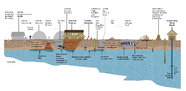
The February 2013 conceptual site model (above) for the Taku Gardens site shows the type and location of all potential sources of contamination that were identified in the investigation, and how and where people, plants or animals could have been exposed to that contamination. (Graphic by Jacobs, CH2M Hill)
The FCS has had a history of mixed uses, including the following:
- Communications and radar facility
- Barracks and company headquarters extending into the northwest corner of the site
- Equipment salvage and/or reclamation yard
- Debris and salvage material disposal in the Chena River oxbow that extends through the site, in trenches in the salvage yard area, and possibly in other local depressions
- Garden plots
- Concrete batch plant and railroad spur
- Possible ammunition storage
- Firefighter training
Only a limited number of written records describing specific activities occurring at the FCS during the course of its history are available. Much of what is known about the site was inferred from examining and comparing historical photographs dating from 1947 to present, the 1958 FWA “Master Plans,” past geographical surveys, and military operations concurrent with similar missions conducted at other locations.
The area was selected for military family housing in 2002 and 2003. Housing construction at this site began mid-2005. A variety of buried metal and debris, including empty drums, some drums with contents, and munitions-related items were found at the surface and in the subsurface at the FCS during the housing construction. The debris, along with associated contaminated soil, tended to be concentrated in former low-lying areas and in pits that were filled and covered before the FCS was developed. Materials and chemicals placed in these former disposal areas are assumed to be the primary sources of contaminated soil and groundwater at the FCS. The pre-construction investigations and surveys, the preliminary source evaluation (PSE), remedial investigation (RI), and post-RI activities conducted between 2003 and 2011 have investigated all significant potential disposal and contaminant source areas at the FCS.
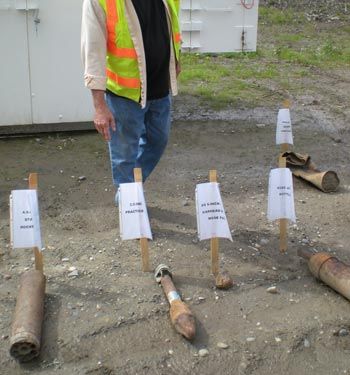
Some of the discarded military munitions unearthed at the Taku Gardens site are shown in this June 2008 photo. (DEC photo)
Institutional Controls
Institutional Controls (ICs) are measures to protect people and the environment from exposure to oil or hazardous substances. Current site-specific ICs for the FCS are:
- Soil Restrictions: Institutional Controls are in place to restrict excavation of soil at a depth greater than 6 inches below ground surface (bgs) by anyone without approval of the Army and concurrence of EPA and DEC. Residential lease agreements will prohibit any excavations or soil disturbances by residents and any violations are subject to enforcement procedures.
- Groundwater Restrictions: Institutional controls prohibit groundwater uses including drinking and other domestic uses such as human and animal consumption, bathing, showering, gardening, irrigation, use on consumable food products, or any other domestic use. Groundwater restrictions also prohibit the installation of dewatering wells, monitoring wells, irrigation, fire suppression, or potable water wells without prior approval from the Army.
- Additional Requirements: Disposal and transport of soil or groundwater removed from OU6 must meet standards for container type; sampling and analysis for potential contamination; marking and labeling; and moving and storage requirements specified in Army Regulations. Soil or groundwater will not be removed from any part of OU6 without written permission from an authorized Army representative and EPA and DEC concurrence and the Army shall notify EPA and DEC of any proposed waste disposal/treatment facility that will be receiving soil or groundwater.
The specific objectives of the ICs at OU6 are as follows:
- Prevent access to or use of the groundwater beneath OU6 until project cleanup levels (PCLs) are met.
- Maintain the effectiveness of the monitored natural attenuation (MNA) remedy for groundwater by developing specific operation and maintenance activities for monitoring well network, which will remain in place until PCLs are met.
- Prevent unauthorized access to soil greater than 6 inches bgs until PCLs are met.
Current Status
The site has been investigated and managed in accordance with all applicable state regulations and CERCLA. The following contaminated media has been investigated:
- Soil: Debris, drums, munitions-related items, and contaminated soil encountered during investigation activities and removal actions were removed to the greatest extent practicable and properly disposed of to prevent future groundwater contamination and to protect the health of future residents, site visitors and site workers. Soil contaminated with petroleum, oil and lubricants (POL) and residual concentrations of 1,2,3-trichloropropane (TCP), volatile organic compounds (VOCs), semi-volatile organic compounds (SVOCs), pesticides, herbicides, and explosive compounds remained in the subsurface between 5 and 15 feet bgs at the completion of the RI. With the exception of diesel range organics (DRO) contaminated soil in the north-central portion of the site, remaining soil contaminants are present at concentrations that do not exceed human health-based cleanup levels.
- Groundwater: Groundwater at the FCS is contaminated with POL and VOCs. Presumed source areas for this groundwater contamination have been removed to the greatest extent practicable. This material was removed during pre-RI construction activities, as IDW during the RI, and during two time-critical removal actions (TCRA) (one pre-RI and one post-RI). Groundwater monitoring at this site began in 2005, continued through the RI, and continues as a biannual monitored natural attenuation (MNA) sampling program. Historical or current exceedances define five groundwater plumes: the trichloroethylene (TCE) plume, the trichloropropane (TCP) plume, the main DRO plume, the MW62 DRO plume, and the MW77 DRO plume. Groundwater monitoring of the plumes at the FCS is ongoing.
- Vapor Intrusion: A sub-slab vapor monitoring program began March/April 2014 to determine the vapor intrusion risk into the residential buildings. The vapor monitoring program was planned for four years:
- Year One: One sub-slab vapor sample was collected for VOCs at each of the 110 residential units for the first sampling event. There were three indoor air sampling events at 12 residential units. All residential buildings were unoccupied during the 2014 to 2015 sampling events.
- Year Two: There were four indoor air sampling events at 12 residential units. All 12 of the residential units were occupied for the 2016 sampling.
- Year Three: One sub-slab vapor sample was collected for VOCs at each of the 110 residential units in 2017. Not all 110 residential units were occupied.
- There was one indoor air sampling event at the 12 occupied residential units in 2018.
After four years of collecting sub-slab samples and indoor air samples, none of the sample results exceeded the site-specific target levels. Based on the vapor intrusion sample results, the potential for intrusion of harmful concentrations of contaminants into indoor air is low. Based on this conclusion and the sites historical data, vapor intrusion sampling has been discontinued.
The site is currently undergoing annual groundwater monitoring with institutional control inspections.
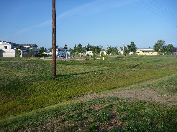
The empty housing development, which covers 54 acres, is shown during the summer of 2013. The whole development was fenced and site access was restricted to limit potential human exposure.
More Information
- Record of Decision, Operable Unit 6, Former Communications Site – Final (January 2014), U.S. Army Corps of Engineers, Alaska District (PDF)
- DEC’s Contaminated Sites Database – There are a number of individual contaminated sites on Fort Wainwright, and updates on the status of each is available on DEC's database. (Project managers update the database entries as time allows; they’re not always up-to-date.)
- Taku Gardens database entry. For a report on the site’s institutional controls, click on the picture of the file in the upper right of the database entry.
- All other sites. Choose “Fort Wainwright" in the city drop-down box.
- The U.S. Army Garrison Alaska website provides general information on what is going on at Fort Wainwright. For information on the U.S. Army’s restoration program, go to the drop down menu at the very top of the page, click on ‘Local Community,’ then ‘Environmental.’
- DEC’s Glossary/Acronyms link is on the bottom of the Contaminated Sites Program’s home page.
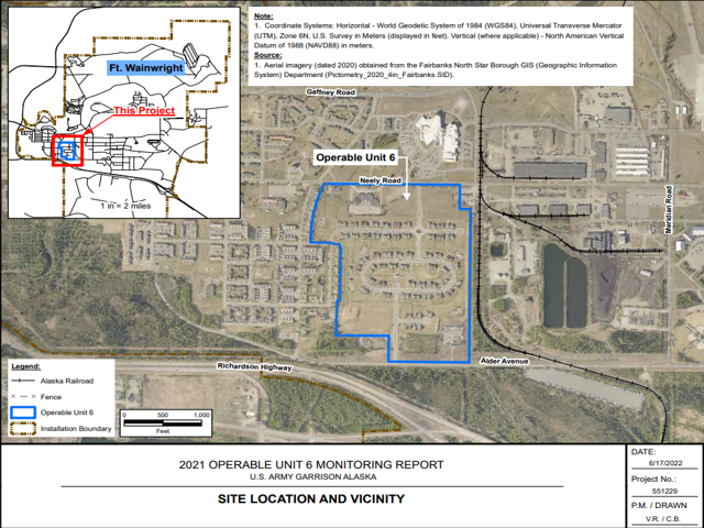
The above 2021 map shows the location of the site on Fort Wainwright.
General DEC Fact Sheets
- Cleanup Process for Contaminated Sites
- How DEC Makes Cleanup Decisions
- Introduction to Groundwater
- Understanding Contaminant Concentrations
- Department of Defense Cleanups
- Environmental Laws and Regulations
- "Environmental Cleanup Methods," June 2009 (PDF 171K)
- Human Health Risk Assessment
- Contaminants in Alaska