Salt Chuck Mine, Mill Area
- View detailed information from the database on this site.
- Database Name: USFS Salt Chuck Mine
- Status: Active
- Location: Thorne Bay
- Latitude: 55.627222
- Longitude: -132.556944
- DEC Contaminated Sites contact: Sarah Durand, Project Manager, 907-262-8223 (Soldotna)
- U.S. Environmental Protection Agency contact: Madi Novak, Remedial Project Manager, 206-553-3141
- U.S. Forest Service contact: Michele Parker, 907-518-1079
- Click on photos or maps for larger versions.
- Contacts updated: 11/4/2025
- Summary updated: 11/4/2025
Site Narrative
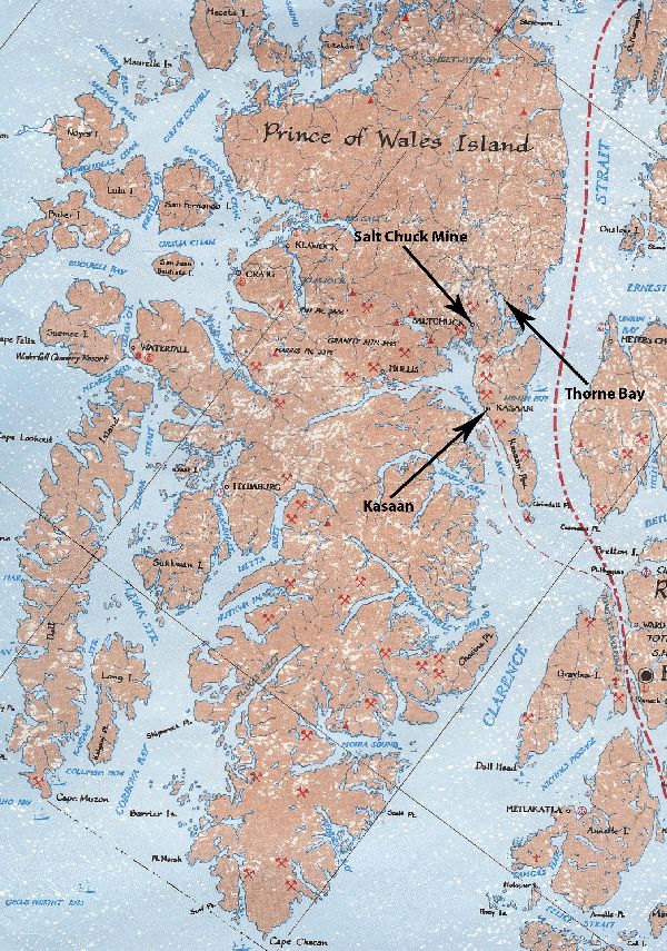
The Salt Chuck Mine is on Prince of Wales Island in the Tongass National Forest and at the northern end of Kasaan Bay. (Map by and courtesy of the Sobay Company of Olympia, Wash.)
Description
The Salt Chuck Mine is an abandoned historic gold, silver, copper and palladium mine on the southeast side of Prince of Wales Island. The site is 4½ miles from Thorne Bay, and is accessible by road, or by water.
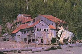
The mine and mill operated from 1905 to 1941, processing more than 326,000 tons of ore. The mine openings are about a half mile uphill from the mill area, which is on the northern shore of Salt Chuck Bay near the mouth of Lake Ellen Creek. The remnants of the mill's equipment are on the site.
An extensive tailings deposit of an estimated 100,000 cubic yards is located mostly in the intertidal zone south of the mill, on state-owned tidelands. Additional tailings were located in the upland area, which is managed by the U.S. Forest Service. The tailings deposits on the whole site – in the intertidal zone and the upland area – cover 23 acres.
As with other abandoned historic mines, the sources of contamination at the mill area are a result of standard practices from an era before environmental regulations, when mines operated without today's permits and reclamation requirements.
The Alaska Department of Natural Resource's Prince of Wales Area Plan identifies the area around the site as “intensive public recreation use.” The Forest Service has public-use cabins and a campground in the area, and Salt Chuck Bay is used for subsistence clamming and crabbing. Lake Ellen Creek supports five species of anadromous fish.
The U.S. Bureau of Land Management first investigated the Salt Chuck Mine's mill from 1995 to 1998. Those investigations led to a more in-depth one conducted by the Forest Service from 2002 to 2007.
In 2007, DEC, Alaska Department of Health (DOH) and U.S. Environmental Protection Agency (EPA) agreed that the site needed additional characterization based on multiple land uses. As a result, the Forest Service further studied the site and finalized an Engineer Evaluation/Cost Analysis to assist with future cleanup work.
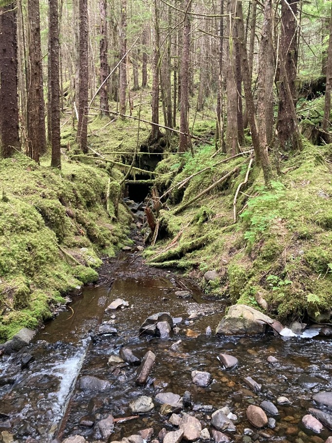
One of the main adits to the mine with remaining ore car rails as seen in 2025. An adit is a nearly horizontal passage from the surface to a mine. (DEC Photo 2025)
On March 2, 2010, the EPA announced it had added the Salt Chuck Mine site to its National Priorities List. The listing makes the site eligible to receive federal funds for long-term cleanup activities.
In 2011, the Forest Service used funding from the American Recovery and Reinvestment Act, along with additional funding, to conduct a non-time critical removal action on the uplands. The Forest Service built a short road to provide access to the site, removed building debris, drums and tanks, and excavated roughly 5,400 cubic yards of petroleum-contaminated soil and metals-contaminated tailings from the uplands.
The EPA collected soil, sediment, water and biota samples at the site in 2011, 2012, and 2013. Those data were used to develop a Remedial Investigation Report, which the EPA finalized in 2018. The report noted that the nature and extent of contamination at the site had been characterized, no unacceptable human health risks were identified, and potential ecological risks were limited to copper in the marine sediment in the tailing's disposal and depositional areas in the bay. Additional background information on EPA’s work at the Salt Chuck Mine site is available on the EPA's website for the mine.
The Forest Service consolidated the remaining historical mining equipment and installed public informational signage about the historical use of the site after the removal action in 2011. (DEC Photo 2025)

Biochar added to a test plot in the tidal area as part of the Treatability Study in 2025. The biochar is placed in multiple layers and covered with sediment. (DEC Photo 2025)
Current Status
Since 2021, the EPA has been collecting additional samples each summer in the bay as part of a treatability study. This study incorporates plots of a substance known as biochar into the contaminated tidal area. Biochar consists of burnt remnants of organic material, similar to charcoal. It is effective at absorbing heavy metals, which may help reduce metal toxicity in contaminated soils. The purpose of the treatability study is to determine whether biochar can reduce the toxicity of metals - particularly copper - in the treated area. The results will be used to support the Feasibility Study (FS), which evaluates potential cleanup options based on their effectiveness, practicality, and cost. These findings will also help guide the Remedial Design process.
The FS is the current stage of the CERCLA remedial process, and the EPA is leading the effort to draft and design the study. . At this stage, different cleanup options – called remedial alternatives – are being developed to address the contamination. The remedial alternatives include excavating contaminated sediments for disposal either out of state or at a specially-designed local landfill, capping the metals-contaminated sediments to limit environmental exposure, and amending the sediments with biochar or a similar material to reduce the effective toxicity. It is likely that the final remedy will combine several of these strategies. Once the preferred remedial alternative is selected from the FS, a Remedial Design will be developed that outlines the technical specifications needed for the remedy.
More Information
Documents related to this contaminated site can be found on the Contaminated Sites Program database.
Contacts
For more information about this site, contact:
Alaska Department of Environmental Conservation
- Sarah Durand, Project Manager
- sarah.durand@alaska.gov
- 907-262-8223
- Stephanie Buss, Program Manager
- stephanie.buss@alaska.gov
- 907-269-7545
U.S. Forest Service
- Michele Parker, Regional Environmental Program Manager
- michelle.parker@usda.gov
- 907-518-1079
U.S. Environmental Protection Agency
- Madi Novak, Remedial Project Manager
- novak.elisabeth@epa.gov
- 503-351-4445