Cook Inlet Geographic Response Strategies: Seward Zone
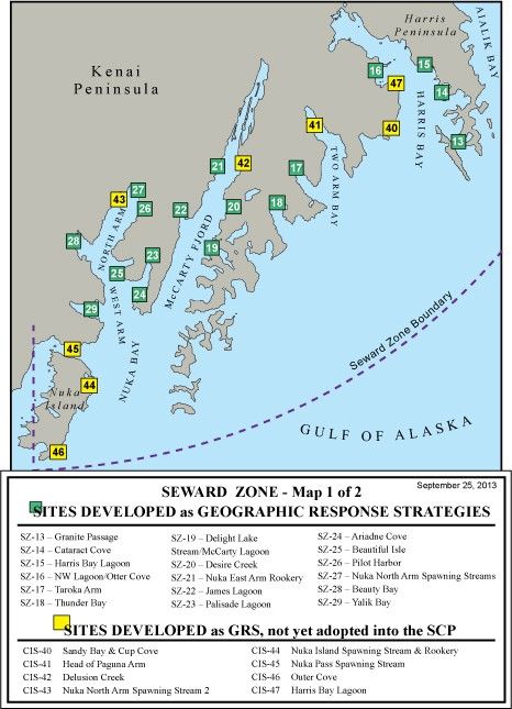
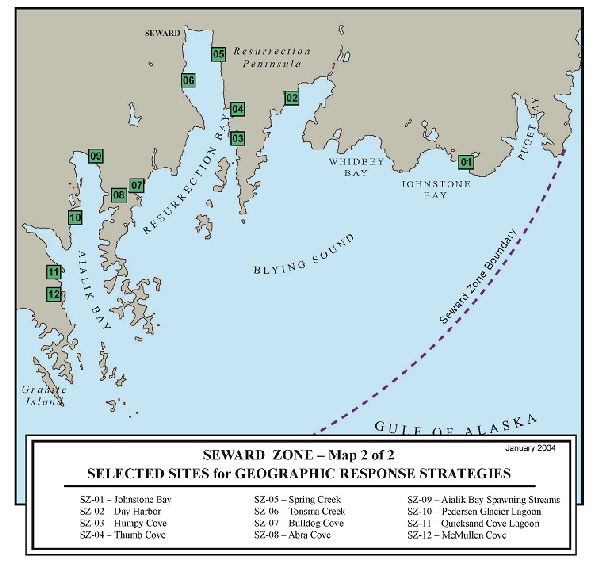
A total of 47 GRS have been developed for the Cook Inlet Seward Zone. In 2003, the workgroup selected 39 sites from the list of candidate sites for GRS development. In 2011, the Prince William Sound Regional Citizens Advisory Council designated funding for the development of additional GRS and a workgroup met to identify high priority sites.
The 2 maps show the GRS selected sites, while the site selection matrix and site selection key summarize the resources at risk for each site. The site selection process took into consideration environmental sensitivity, risk of being impacted from a waterborne spill, and feasibility of successfully protecting the site with existing technology.
Site Selection Documents
- Site Selection Matrix (PDF 46K)
- Site Selection Key (PDF 20K)
- Summary of the November 2011 workgroup meeting
Geographic Response Strategies (GRS)
- CIS-01 Johnstone Bay-Salmon Stream (PDF 852K)
- CIS-02 Day Harbor (PDF 1.6M)
- CIS-03 Humpy Cove (PDF 1.7M)
- CIS-04 Thumb Cove (PDF 1.9M)
- CIS-05 Spring Creek (PDF 1.4M)
- CIS-06 Tonsina Creek (PDF 1.4M)
- CIS-07 Bulldog Cove (PDF 1.6M)
- CIS-08 Abra Cove (PDF 1.3M)
- CIS-09 Aialik Bay Spawning Streams (PDF 609K)
- CIS-10 Pedersen Glacier Lagoon (PDF 1.7M)
- CIS-11 Quicksand Cove Lagoon (PDF 1.2M)
- CIS-12 McMullen Cove (PDF 831K)
- CIS-13 Granite Passage (PDF 1.5M)
- CIS-14 Cataract Cove (PDF 1.4M)
- CIS-15 Harris Bay Lagoon (PDF 1.4M)
- CIS-16 Otter Cove (PDF 1.6M)
- CIS-17 Taroka Arm (PDF 1.8M)
- CIS-18 Thunder Bay (PDF 1.6M)
- CIS-19 Delight Lake Stream/McCarty Lagoon (PDF 1.7M)
- CIS-20 Desire Creek (PDF 1.6M)
- CIS-21 Nuka East Arm Rookery (PDF 1.2M)
- CIS-22 James Lagoon (PDF 1.5M)
- CIS-23 Palisade Lagoon (PDF 1.9M)
- CIS-24 Ariadne Cove (PDF 1.4M)
- CIS-25 Beautiful Isle (PDF 1.3M)
- CIS-26 Pilot Harbor (PDF 1.5M)
- CIS-27 Nuka N. Arm Spawning Streams (PDF 1.6M)
- CIS-28 Beauty Bay (PDF 1.9M)
- CIS-29 Yalik Bay (PDF 2.2M)
- CIS-30 Head of Puget Bay (PDF 1M)
- CIS-31 Whidbey Bay (PDF 818K)
- CIS-32 Horsehead Bay (PDF 760K)
- CIS-33 Head of Day Harbor (PDF 857K)
- CIS-34 Eldorado Narrow/ Cape Resurrection (PDF 451K)
- CIS-35 Resurrection Bay/ Seward Lagoon (PDF 1M)
- CIS-36 Bear Glacier Lagoon (PDF 1.3M)
- CIS-37 Porcupine Cove (PDF 682K)
- CIS-38 Chiswell Island (PDF 404K)
- CIS-39 Holgate Arm (PDF 414K)
- CIS-40 Sandy Bay & Cup Cove (PDF 799K)
- CIS-41 Head of Paguna Arm (PDF 479K)
- CIS-42 Delusion Creek (PDF 487K)
- CIS-43 Nuka N. Arm Spawning Stream 2 (PDF 448K)
- CIS-44 Nuka Island Spawning Stream & Rookery (PDF 499K)
- CIS-45 Nuka Pass Spawning Stream (PDF 490K)
- CIS-46 Outer Cove (PDF 458K)
GRS Updates Pending Approval
- Currently no updates pending approval
The Geographic Response Strategies (GRS) and tactics described on this site and in the area plans, are NOT prescriptive in nature. They are recommended deployment configurations for initial responders. They can, and should, be adjusted to fit the current situation and environmental conditions.
For More Information
- See the GRS Links menu on this page (includes links to GRS frequently asked questions, a site evaluation form, and more information on the site selection process)
- Contact DEC at dec.spar.grs@alaska.gov


 Indicates an external site.