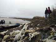
South Side Alakanuk Dumpsite
- View detailed information from the database on this site.
- Database Name: South Side Dumpsite - Alakanuk
- Status: Informational
- Location: Alakanuk
- Latitude: 62.685556
- Longitude: -164.653611
-
Key DBAC Services:
- Site Assessment
- DBACs Awarded: 2008
- DEC File Number: 2403.38.003
DEC Contaminated Sites contact: Lisa Griswold, 907-269-2021
Site Narrative
- Requested by the Native Village of Alakanuk

Eroding former dumpsite at Alakanuk
This site is located along the bank of the Alakanuk River, a major southern channel of the Yukon River. This beach is used primarily as a boat landing for residents and commercial fishermen and is considered one of the few areas suitable for this use. Erosion along the riverbank has exposed a variety of wastes, now depositing directly into the river, habitat to anadromous fish populations. Concerns include both chemical and physical hazards. The Yukon River Inter-Tribal Watershed Council conducted a Phase I environmental site assessment of this site in 2006, and had ranked this as one of the two priority sites of more than 100 sites surveyed in their region.
The work associated with this project included a review of previous rural dumpsite characterizations conducted by both EPA and DEC, and provided a summary of expected concerns with these sites. It will identify a management plan or evaluation of options to render the properties useable and safe. Such a management plan would benefit these and other communities by helping to identify what actions can be taken locally to minimize impacts caused by abandoned and eroding dumpsites.
