Alaska’s Watershed Prioritization Map
(Preview Only - Limited Functionality)
This map was created by the Alaska Department of Environmental Conservation in partnership with the Alaska Clean Water Actions committee to provide a statewide data-driven, objective methodology for evaluating and prioritizing watersheds for the ACWA program. The map displays information collected from a variety of publicly available GIS datasets and can be used to inform watershed issues and potential projects.
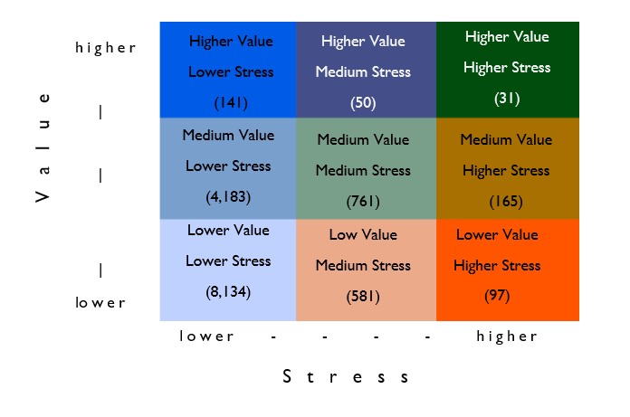
Zoom in and click on a dot to learn about the prioritization ranking for that watershed. Click on the Legend icon to the upper left to view the legend or expand the fields below for the prioritization ranking key and prioritization matrix that lists the number of watersheds in each ranking category. Follow this link to see a table of the criteria scoring details..
Prioritization Ranking Key
| Scoring Acronym | Definition | Data Source |
|---|---|---|
| CMS | Conservation Management Status | USGS |
| IFR | Instream Flow Reservation | ADF&G, UAA-ACCS, with ADNR data support |
| PopDens_Val | Population Density - Value | US Census Bureau |
| AWC | Anadromous Waters Catalog | ADF&G |
| Spawn | Spawning Habitat - AWC | ADF&G |
| WSR | Wild and Scenic River | BLM/NPS |
| CS | Contaminated Sites | ADEC |
| Discharge | Water Discharges | ADEC |
| FishPass | Fish Passage | ADF&G |
| Impaired | Impaired Waters | ADEC |
| LargeProject | Large Project Planned | ADNR, BLM, USACE |
| MineClaims | Mining Claims - current | ADNR, BLM |
| MiningFprint_historic | Mining Footprint - historic | UAA-ACCS |
| HistMineDensity | Mine Density - historic | USGS |
| PopDen1 | Population Density | US Census Bureau |
| StreamXing | Road - Stream crossings | ADOT |
| WQMonitor | Water Quality monitoring - absence | ADEC |
Prioritization Matrix with Number of Watersheds

- Program Manager: Laura Eldred
- (907) 376-1855
- Contact information

 Indicates an external site.