Regional Haze Planning
Program Basics
Class I Areas
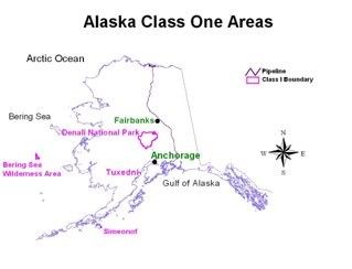
DEC is tasked with protecting and improving the visibility and air quality at four ‘Class I Areas’ within the state. These were parks and wilderness areas over 5000 acres at the time that the designation and protections were established in the 1977 Clean Air Act Amendment. Within Alaska, the four areas which met this designation were: Denali National Park, Tuxedni Wilderness Area, Simeonof Wilderness Area, and the Bering Sea Wilderness Area. DEC builds the state’s approach to protecting and improving the visibility of these four areas by using available data from visibility monitors located in or near these areas. Only the Bering Sea Wilderness Area lacks any data, because it is too distant for monitors to be operated and maintained.
Program Goals
States are required to generate “state implementation plans”, known as a SIP, to demonstrate how each state has made progress over the previous ten-year implementation period and how it will ensure improvement in the next implementation period. In this SIP, Alaska must show visibility improvement during the 20% Most Impaired Days (MID) and cannot have declining visibility quality during the 20% Clearest Days. This is intended to assist the state in meeting the goal of the federal program, which is to return each Class I Area to natural visibility conditions by the end of 2064.
Regulatory Changes to the Regional Haze Rule
Between the formal adoption of the First Regional Haze Plan in 2012 and now, EPA initiated a series of regulatory changes to further improve program outcomes and assist states in calculating visibility impairing pollutants. See the table below for a more specific outlining of the regulatory and statutory changes or visit the EPA Visibility Regulatory Actions website
|
Key Similarities and Differences: First and Second Implementation Period |
|---|
|
Similarities: 1st and 2nd Implementation Period: |
|
|
Differences: 1st and 2nd Implementation Period: |
|
Alaska SIP Planning Steps:
Step 1: Ambient Data Analysis
Identify the 20 percent most anthropogenic impaired days and the 20 percent clearest days; determine baseline, current, and natural visibility conditions for each Class I Area within the state.
Step 2: Determination of affected Class I areas in other states
- (This is not applicable to Alaska.)
Step 3: Selection of sources for analysis
- Alaska is to review its emissions inventory data and select sources or source sectors for emissions analysis.
- Develop data on the Four Statutory Factors.
Step 4: Characterization of Factors for Emissions Control Measures
Step 5: Decisions on what control measures are necessary to make reasonable progress
- After examining and analyzing the available data, ADEC will decide what control measures are needed or necessary for the state to make reasonable progress.
Step 6: Regional scale modeling or analysis of the long-term strategy to set Reasonable Progress Goals for 2028.
- Note: Alaska has limited ability for modeling and will be relying on analysis tools versus modeling tools.
Step 7: Progress, Degradation, and URP glidepath check
Step 8: Additional requirements for Regional Haze SIPs
- Federal Land Manager Consultation
- Public Review
Unique Challenges for Planning in Alaska
Alaska shares the status of non-contiguous state with Hawaii and the Commonwealth of Puerto Rico, meaning that its approach to visibility improvement is different than those of the Continental United States. A large part of this difference is because of Alaska’s geographical location at the northwestern corner of the Americas and within the Arctic Circle. As a result, the state’s Class I Areas can be exposed to a variety of internationally generated pollutants which are carried to our state by prevailing wind and weather patterns.
In addition, the state has a very active geology, with volcanoes, glaciers, and oceanic actions which can generate large amounts of natural visibility impairment. Lastly, there has been an increase in the size and severity of wildfires both within and outside of Alaska in both Canada and the Russian Far East. This wildfire smoke can be transported by the same wind and weather patterns as international pollutants, impairing visibility at protected National Parks and Wilderness Areas.
As a result, the amount of controllable pollution for state planners is greatly different than other states. The graphic below best shows this planning approach:
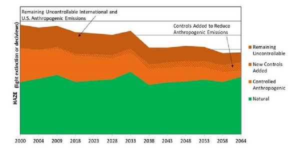
Controllable, Uncontrollable, and Natural Haze Emissions Theoretical Progress Through 2064 (Figure 5 of the Western Regional Air Partnership (WRAP) Monitoring Data & Glide Path 2018 Work Summary Document)
More Resources
The information available on this webpage only covers a small amount of the larger information available on Regional Haze planning in both Alaska and the rest of the Western United States. Alaska participates in the Western States Regional Air Partnership (WRAP) to assist in its data analysis and policy planning efforts. This includes the TSS website, which provides a compilation of visibility data, graphs, glideslopes, and other visual representations of trends and historical haze readings back to the start of the program in 2000.
Alaska also assisted with the writing of the WRAP Storyboard, which provides general information on the history of the Regional Haze program in the Western U.S., the background for why the Regional Haze program was initiated, and potential future reductions to visibility impairing pollutants.
EPA provides all its guidance and regulatory documents online for the public to review. This includes the 1977 Clean Air Act Amendment, the 1999 Regional Haze Rule, and all supporting guidance and regulatory change documents. EPA promulgated a significant rule change in January 2017 and a series of guidance documents assisting states in their visibility calculations. These changes were summarized in the table which provided differences and similarities between the two planning periods. However, there are several other changes which were not included in the summary table because they were not applicable to Alaska’s planning process.
General informational websites:
- Western Regional Air Partnership (WRAP) Website
- WRAP Storyboard
- WRAP TSS
- EPA Regional Haze website
- Regional Haze Guidance Documents
- EPA Region 10 website
Links to specific regulatory and guidance documents:
- Text of 1977 Clean Air Act Amendment
- Text of 1990 Clean Air Act Amendment
- Text of 1999 Regional Haze Rule
- Text of 2017 Regional Haze Rule Revision
- Text of August 2019 Regional Haze Guidance
- Recommendation for the Use of Patched and Substituted Data
- Technical Addendum on Use of Patched and Substituted Data
- Technical Support Document for EPA Regional Haze Modeling for AK, HI, and VI
What’s Next?
ADEC has completed writing and editing the Second Regional Haze Plan in cooperation with our federal partners and stationary source owners. The plan was put forth for public comment on March 31, 2022, and its public comment window ended May 25; one public information session was held in May to allow the public to engage in discussions with ADEC personnel. ADEC completed final edits and responded to comments received by the end of June and submitted the plan for adoption on July 5, 2022. The plan has been adopted and signed by the Lt. Governor and has been submitted to the EPA for review and approval.
ADEC will begin reviewing data to write the state’s Regional Haze Progress Report in 2023 for submission to federal partners in January 2024 for their four-month (120 day) review to provide comments and edits to ADEC. The Progress Report is due to EPA in January 2025.
The Third Regional Haze Implementation Plan is due to EPA by July 2028.
Points of Contact
To request more information about Alaska’s Regional Haze program, please contact the following persons:
- Morgan Frank, ADEC Air Quality - Non-Point Mobile Sources Section: Morgan Frank
 Indicates an external site.