Proposed Changes To Alaska’s Planning Structure
Decommissioning the Unified Plan and Sub-area Plans to a Regional Contingency Plan and four Area Contingency Plans
The public review period is from June 18 to July 17, 2018.
The Alaska Department of Environmental Conservation, U.S. Coast Guard, and the Environmental Protection Agency are seeking public input on the structural changes from the multi-agency response planning structure currently known as the Alaska Federal/State Preparedness Plan for Response to Oil and Hazardous Substance Discharges/Releases (the Unified Plan) and the 10 Sub-area Plans, to a Regional Plan and four Area Plans.
Documents and Links
- Notice of Public Comment Period
- State of Alaska public notice identifying how and when to comment
- Understanding Alaska’s Planning Structural Reorganization (PDF 485K)
- “How to” resource for reading, comprehending and using the new Alaska contingency planning documents
- Structural Reorganization Supplemental (PDF 415K)
- Table outlining the key differences between the Unified Plan/Sub-area Plans and the new RCP/ACP format
- Comment Matrix (DOCX 24K) (PDF 187K)
- Form providing stakeholders with a template for commenting on the subject document
- Contingency Plans
- Regional/Area Planning Proposal webpage
- Webpage providing a brief overview of the planning proposal as well as links to supplemental documents and more detailed maps of the proposed Areas and Geographic Zones
Proposed Area Boundaries and Geographic Zones Map (click image to enlarge)
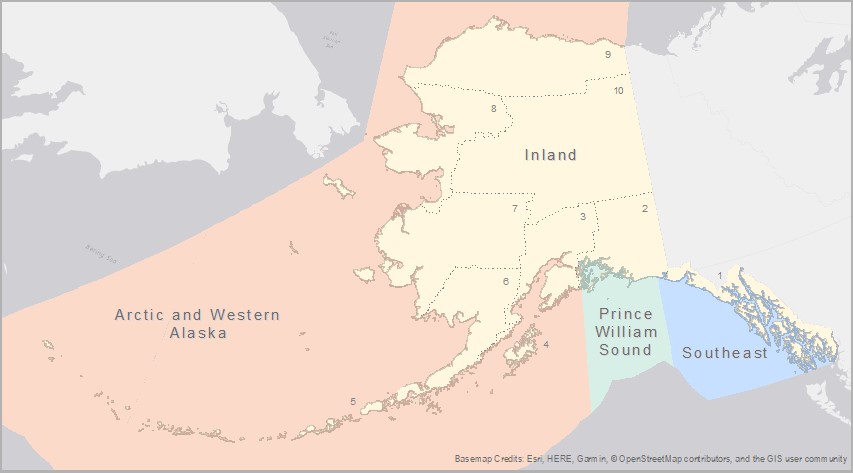
Geographic Zones mimic the boundaries of the existing 10 subareas: 1) Southeast Alaska, 2) Prince William Sound, 3) Cook Inlet, 4) Kodiak Island, 5) Aleutians, 6) Bristol Bay, 7) Western Alaska, 8) Northwest Arctic, 9) North Slope, and 10) Interior Alaska.
 Indicates an external site.