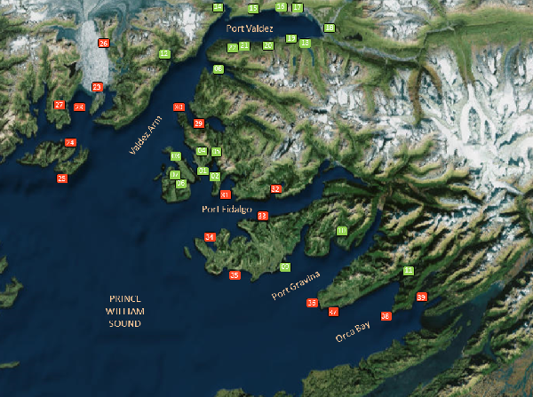
Prince William Sound Geographic Response Strategies: Northeast Zone

The workgroup selected 39 sites from the list of candidate sites for GRS development. The map shows the GRS selected sites, while the site selection matrix and site selection key summarize the resources at risk for each site. The site selection process took into consideration environmental sensitivity, risk of being impacted from a waterborne spill, and feasibility of successfully protecting the site with existing technology.
Site Selection Documents
Geographic Response Strategies (GRS)
- NE-01 Tatitlek Harbor (PDF 1.8M)
- NE-02 West Boulder Bay (PDF 2.3M)
- NE-03 West Tatitlek Narrows (PDF 1.9M)
- NE-04 Virgin Bay (PDF 2.5M)
- NE-05 Head of Boulder Bay (PDF 2.2M)
- NE-06 Cloudman Bay-Bligh Is. (PDF 2.1M)
- NE-07 West Bay-Bligh Is. (PDF 1.8M)
- NE-08 Jack Bay (PDF 4.4M)
- NE-09 Hells Hole (PDF 2M)
- NE-10 Olsen Bay (PDF 3.4M)
- NE-11 Upper Sheep Bay (PDF 3.2M)
- NE-12 Sawmill Bay (PDF 3.4M)
- NE-13 Solomon Gulch Hatchery (PDF 3M)
- NE-14 Shoup Bay (PDF 3.5M)
- NE-15 Gold Creek (PDF 3.2M)
- NE-16 Mineral Creek (PDF 3.3M
- NE-17 Valdez Duck Flats (PDF 3.3M
- NE-18 Robe/Lowe Rivers (PDF 2.2M)
- NE-19 Allison Creek (PDF 3.4M)
- NE-20 Sawmill/Salmon Creeks (PDF 3.5M)
- NE-21 Seven Mile Beach Stream (PDF 3.8M)
- NE-22 Anderson Bay (PDF 3.2M)
- NE-23 Heather Bay (PDF 552K)
- NE-24 North Glacier Island (PDF 520K)
- NE-25 Bull Head (PDF 435K)
- NE-26 Columbia Bay Stream (PDF 505K)
- NE-27 Granite Cove (PDF 592K)
- NE-28 Columbia Bay Island (PDF 595K)
- NE-29 Galena Bay (PDF 730K)
- NE-30 Entrance to Galena Bay and Rocky Point (PDF 656K)
- NE-31 Landlocked Bay (PDF 1.2M)
- NE-32 Fish Bay (PDF 684K)
- NE-33 Irish Cove (PDF 622K)
- NE-34 Snug Corner Cove (PDF 752K)
- NE-35 Knowles Bay (PDF 949K)
- NE-36 Gravina Island (PDF 819K)
- NE-37 Gravina Point Lagoon (PDF 694K)
- NE-38 Sheep Point (PDF 973K)
- NE-39 Simpson Bay (PDF 734K)
GRS Updates Pending Approval
- NE-22 Anderson Bay (PDF 225K) -November 2016
- NE-19 Allison Creek (PDF 203K) -December 2016
- NE-20 Sawmill/Salmon Creek (PDF 216K) -December 2016
- NE-15 Gold Creek (PDF 223K) -January 2017
- NE-31 Landlocked Bay (PDF 266K) -January 2017
- NE-32 Fish Bay (PDF 254K) -January 2017
- NE-33 Irish Cove (PDF 221K) -January 2017
- NE-34 Snug Corner Cove (PDF 224K) -February 2017
- NE-35 Knowles Bay (PDF 244K) -February 2017
- NE-37 Gravina Point Lagoon (PDF 210K) -March 2017
- NE-11 Upper Sheep Bay (PDF 275K) -April 2017
- NE-39 Simpson Bay (PDF 251K) -April 2017
- NE-16 Mineral Creek (PDF 193K) -April 2017
- NE-18 Robe/Lowe Rivers (PDF 208K) -April 2017
- NE-14 Shoup Bay (PDF 236K) -April 2017
- NE-21 Seven Mile Beach Stream (PDF 211K) -April 2017
- NE-36 Gravina Island (PDF 217K) -April 2017
- NE-38 Sheep Point (PDF 236K) -April 2017
- NE-23 Heather Bay (PDF 237K ) -November 2017
- NE-28 Columbia Bay Island (PDF 212K) -November 2017
- NE-24 North Glacier Island (PDF 229K) -December 2017
- NE-26 Columbia Bay Stream (PDF 212K) -December 2017
- NE-13 Solomon Gulch Hatchery (PDF 225K) -December 2017
- NE-17 Valdez Duck Flats (PDF 194K) -December 2017
The Geographic Response Strategies (GRS) and tactics described on this site and in the area plans, are NOT prescriptive in nature. They are recommended deployment configurations for initial responders. They can, and should, be adjusted to fit the current situation and environmental conditions.
For More Information
- See the GRS Links menu on this page (includes links to GRS frequently asked questions, a site evaluation form, and more information on the site selection process)
- Contact DEC at dec.spar.grs@alaska.gov

 Indicates an external site.