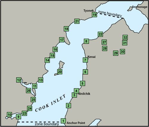
Cook Inlet Geographic Response Strategies: Central Zone

During the initial development phase, the workgroup developed GRS for 22 sites in the Cook Inlet Central Zone. In 2010 Lake Clark National Park and Preserve developed an additional 4 sites and revised 3 more within the Park’s boundaries. In 2011 DEC added 6 sites based on strategies deployed during a 2010 response to an oil spill in the Swanson River field.
The map shows the GRS selected sites, while the site selection matrix and site selection key summarize the resources at risk for each site. The site selection process took into consideration environmental sensitivity, risk of being impacted from a waterborne spill, and feasibility of successfully protecting the site with existing technology.
Site Selection Documents
Geographic Response Strategies (GRS)
- CCI-01 Anchor River (PDF 2M)
- CCI-02 Stariski Creek (PDF 1.8M)
- CCI-03 Deep Creek (PDF 1.6M)
- CCI-04 Ninilchik River (PDF 1.5M)
- CCI-05 Clam Gulch (PDF 1.6M)
- CCI-06 Kasilof River (PDF 686K)
- CCI-07 Kenai River (PDF 1.3M)
- CCI-08 East Foreland (PDF 1.3M)
- CCI-09 Gull Island (PDF 420K)
- CCI-10 Chinitna Bay (PDF 1M)
- CCI-11 Crescent River (PDF 1.5M)
- CCI-12 Tuxedni River (PDF 496K)
- CCI-13 Polly Creek (PDF 1.1M)
- CCI-14 Little Jack Slough PDF 1.1M)
- CCI-15 Drift River (PDF 976K)
- CCI-16 Big River (PDF 841K)
- CCI-17 Kustatan River (PDF 983K)
- CCI-18 McArthur River (PDF 1M)
- CCI-19 Chuitna River (PDF 1.1M)
- CCI-20 Swamp Creek (PDF 1.1M)
- CCI-21 Middle River (PDF 916K)
- CCI-22 Swanson River (PDF 1.8M)
- CCI-23 Shelter Creek (PDF 1.5M)
- CCI-24 Silver Salmon (PDF 521K)
- CCI-25 Johnson River (PDF 1.3M)
- CCI-26 Tuxedni Bay (PDF 1.9M)
- CCI-27 Swanson River Mile 1.5 (PDF 3.4M)
- CCI-28 Swanson River Mile 6.8 (PDF 5.6M)
- CCI-29 Swanson River Mile 18.5 (PDF 2.3M)
- CCI-30 Swanson River Mile 19.2 (PDF 2.1M)
- CCI-31 Swanson River Mile 21.85 (PDF 1M)
- CCI-32 Swanson River Mile 22.7 (PDF 2.1M)
GRS Updates Pending Approval
- CCI-01 Anchor River (PDF 243K)
- CCI-06 Kasilof River (PDF 214K)
- CCI-08 East Forelands (PDF 205K)
- CCI-09 Gull Island (PDF 228K)
- CCI-11 Crescent River (PDF 218K)
- CCI-12 Tuxedni River (PDF 220K)
- CCI-13 Polly Creek (PDF 219K)
- CCI-15 Drift River (PDF 197K)
- CCI-16 Big River (PDF 213K)
- CCI-17 Kustatan River (PDF 202K)
- CCI-18 McArthur River (PDF 210K)
- CCI-19 Chuitna River (PDF 231K)
- CCI-20 Swamp Creek (PDF 237K)
- CCI-21 Middle River (PDF 221K)
- CCI-22 Swanson River (PDF 253K)
- CCI-23 Shelter Creek (PDF 262K)
- CCI-24 Silver Salmon Creek (PDF 216K)
- CCI-25 Johnson River (PDF 212K)
- Cook Inlet OHA GRS Updates (PDF 121K)
The Geographic Response Strategies (GRS) and tactics described on this site and in the area plans, are NOT prescriptive in nature. They are recommended deployment configurations for initial responders. They can, and should, be adjusted to fit the current situation and environmental conditions.
For More Information
- See the GRS Links menu on this page (includes links to GRS frequently asked questions, a site evaluation form, and more information on the site selection process)
- Contact DEC at dec.spar.grs@alaska.gov

 Indicates an external site.